The item illustrated and described below is sold, but we
have another example in stock. To view the example which
is currently being offered for sale, click the
"View Details" button below.


|
||

|

|
|

|
Stock# 14398
Description
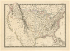
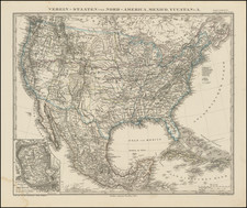
Highly detailed map of the United States, illustrating a number of the transitional Trans-Mississippi West territorial boundaries on the eve of the Civil War. Washington and Oregon Territories extend from the Pacific to the Rocky Mountains. Utah and New Mexico Territories extend from California to the Rocky Mountains. Arizona appears in a very curious configuration south of the Gila River only. Kanzas Territory extens from Missouri to the Rocky Mountains. Nebraska Territory runs from Kansas to the Rockies and the Canadian Border. Misshapen Texas, with exellent detail. Nice detail in the Colorado region, on the eve of its becoming a territory. Excellent detail throughout the Transmississippi West.
![[ Massive Misplace Idaho Territory ] The United States of North America.](https://storage.googleapis.com/raremaps/img/small/99361.jpg)