


|
||

|

|
|

|
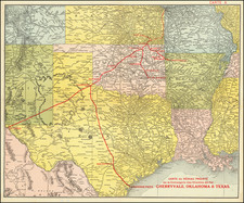
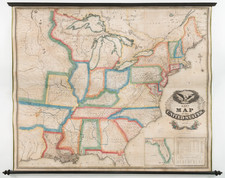
Unrecorded 1829 example of Lay's wall map of the United States.
This example of Lay's map is unique in that it emphasizes in blue outline coloring the major Indian Regions of the US, especially those in Georgia, Mississippi, Alabama Michigan, Illinois, Indiana and Missouri. A number of early routes of exploration west of the Mississippi are shown and Texas is named, on the eve of its land boom, with Austin's settlement noted.
Streeter noted that this was the earliest appearance of Austin's Settlement on a printed map, with the exception of a rare Mexico City imprint, known in only one example. Streeter notes that the settlement, likely intended to be San Felipe de Austin, is incorrectly shown on the east bank of the Colorado River. The mythical Presidio of Nacogdoches is shown, not far from the coast between Galveston Bay and the Sabine River. St. Louis Bay is shown at the mouth of the Brazos. Streeter notes the existence of the 1827 and 1830 editions, but not this 1829 edition.
The later editions, after 1832, offer corrections to the Texas details. Streeter 1094.