


|
||

|

|
|

|
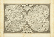
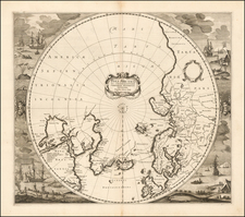
Striking full color example of Hondius' map of the North Polar Regions. With the advances in the knowledge of the Arctic, Mercator's map of 1595 had become obsolete by the 1630s. For the 1636 English edition of the Mercator Hondius Atlas, Hondius engraved a new polar map. The first two editions issued in 1636 contained no decorative vignettes on the sides. The German edition issued in 1636 was the first decorative edition. Hondius drew on the Cartography of Herny Briggs for his model of Hudson's Bay, supplemented buy Thomas James map of 1633. The usual confusion appears around Frobisher's Strait. The prospect of a NW Passage is left open, as is the entire Northwestern portion of North America. Dutch nomenclature appears along the coas of Labrador. The map was issued from 1636 to the 1660s and was later reissued by DeWit. French text on the verso. Nice wide margins and attractive full color.
Henricus Hondius (1597-1651) was a Dutch engraver and mapmaker, a member of a prominent cartographic family. His father, Jodocus Hondius, was also an engraver and geographer. While working with his father, Henricus was instrumental in the expansion and republishing of Mercator’s atlas, first published in 1595 and republished by Hondius in 1606.
Upon his father’s death in 1612, Henricus and his brother, Jodocus the Younger, took over the business. He set up his own shop in 1621, where he continued to release new editions of the Mercator atlas. Later, he partnered with his brother-in-law, Jan Janssonius, in continuing to expand and publish Mercator’s atlas, which would become known as the Mercator-Hondius-Janssonius atlas. Born and based in Amsterdam, he died there in 1651.