|
||

|

|
|

|
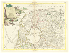
This map, created by Frederick de Wit, depicts the seventeen provinces of the Low Countries (Germania Inferior). It is highly detailed and includes numerous towns, cities, rivers, and other geographical features. The map is adorned with a large, decorative cartouche on the left, which includes a coat of arms and a list of the provinces. At the bottom of the cartouche, there is the crest of Johan Munter. Munster was a wealthy merchant in Amsterdam who held several posts of honour in Amsterdam. He became commissioner of the exchange bank, he was 'Schepen' [city councillor], was a member of the governing body of the V.O.C. and finally became mayor of the city.
Another cartouche in the upper right corner features allegorical figures.
De Wit (1629 ca.-1706) was a mapmaker and mapseller who was born in Gouda but who worked and died in Amsterdam. He moved to the city in 1648, where he opened a printing operation under the name of The Three Crabs; later, he changed the name of his shop to The White Chart. From the 1660s onward, he published atlases with a variety of maps; he is best known for these atlases and his Dutch town maps. After Frederik’s death in 1706, his wife Maria ran the shop for four years before selling it. Their son, Franciscus, was a stockfish merchant and had no interest in the map shop. At the auction to liquidate the de Wit stock, most of the plates went to Pieter Mortier, whose firm eventually became Covens & Mortier, one of the biggest cartography houses of the eighteenth century.
![Ducatus Iuliacensis, Cliviensis, Montensis: et Comitatus Marciae et Rapens-Bergae, finitimaeque eis Regiones [The Duchy of Jülich, Kleve, and Berg, and the Counties of Mark and Ravenstein, and the neighboring regions.]](https://storage.googleapis.com/raremaps/img/small/75285.jpg)
![[ Holy Roman Empire ] Nova Totius Germaniae Descriptio Geographica](https://storage.googleapis.com/raremaps/img/small/95672.jpg)