|
||

|

|
|

|
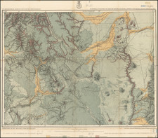
This topographical map represents a detailed survey of part of central New Mexico. It was produced under the direction of the Secretary of War and showcases geographical features with contour lines, hachures, and color coding for different land classifications. The map features various annotations, including a key that distinguishes agricultural and timber land, grazing land, and areas of arid and barren soil. Prominent features such as mountain ranges, valleys, and watercourses are clearly delineated. The scale is 1 inch to 4 miles.
The Wheeler Survey was a significant part of the U.S. government's efforts in the late 19th century to map the Western United States. It aimed to assess the geographical and natural resources to aid in westward expansion and development. This particular map, part of the survey's atlas, highlights the intricate details of the land and was an essential tool for understanding the region's agricultural and timber potential.
Provenance
Colonel George Ruhlen (1884-1971), noted Southern California historical geographer.
Manuscript Annotations
The map was annotated by George Ruhlen with three red triangles representing "Kearny's Camps" along the Rio Grande. These refer to the historical encampments of Brigadier General Stephen W. Kearny during the Mexican-American War (1846-1848). Kearny led the Army of the West, a force of approximately 1,700 men, on a mission to capture New Mexico and California for the United States.