


|
||

|

|
|

|
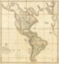
Rare set of 18 maps of America on a single sheet
This monumental work by Pierre Du Val can be described as a single sheet atlas of the Americas, comprised of eighteen important maps showing new discoveries, myths, and legends.
This work embodies the 17th-century wonder and intrigue of the New World during the age of discovery. The detailed cartography reflects the contemporary understanding of geography, merging factual data with speculative elements that captivated the imagination of Europeans.
North America Maps:
-
Le Canada (Canada): Based on Sanson's 1656 map, it depicts the Great Lakes and the Hudson Bay, showcasing early French explorations and settlements.
-
La Nle. Espagne (New Spain, covering Mexico and Central America): Another map following Sanson's work, it covers Mexico and Central America, emphasizing the wealth and significance of New Spain in the colonial era.
-
Le N. Mexique (New Mexico, Southwestern United States and California): This map is notable for potentially being the first to show California as an island, a myth prevalent at the time. It predates or coincides with Sanson's Audience de Guadalajara map.
-
La Floride (Florida and Southeastern United States): Based on Sanson's 1656 depiction, this map illustrates the southeastern United States, detailing Spanish exploration and colonial claims.
-
La Virginie (Virginia, United States): This small map focuses on the Virginia colony, including the Chesapeake Bay, highlighting English colonial efforts.
-
La Nle. Holande (New Holland, modern-day New York): Depicts New Holland, featuring the Hudson River, emphasizing Dutch settlements and influence in the region.
-
La Nle. Suede (New Sweden, modern-day Delaware,): The first map to focus on the Delaware River, representing the Swedish colonial presence in North America.
-
Le Nouveau Danemarq (New Denmark, Greenland and parts of northeastern Canada): Shows Greenland and parts of northeastern Canada, depicting Danish claims in the Arctic region, labeled as Mer Christiane.
- La Castille d'Or (Castilla de Oro, modern-day Panama and Colombia): Depicts parts of modern-day Panama and Colombia, highlighting Spanish colonial interests and trade routes.
-
Le Perou (Peru): Covers the western coast of South America, detailing Peru's rich history and geography.
-
Le Bresil (Brazil): Illustrates Brazil, focusing on the Portuguese colonies and interactions with indigenous tribes.
-
Le Chili (Chile): Shows the region of Chile, emphasizing its mineral wealth and Spanish conquest.
-
Le Paraguay (Paraguay): Highlights the major rivers and settlements in Paraguay, focusing on Spanish colonial activities.
-
La Magellanique (Magellanica, including Tierra del Fuego and parts of southern Argentina and Chile): Depicts the southernmost part of South America, including the Strait of Magellan, and mentions the mythical giants of Patagonia and El Dorado.
-
La Guiane (Guiana, modern-day Guyana, Suriname, and French Guiana): Illustrates the Guiana region, with a focus on the mythical city of El Dorado near Lake Parime.
-
Les Isles Antilles (Caribbean Islands): Shows the Caribbean islands, detailing Spanish, French, and English colonial claims.
-
Le Mexique (Mexico): Emphasizes Mexico's wealth, particularly its silver mines, and includes details on Central American geography.
Du Val's map is notable for its reluctance to depict Tierra del Fuego as an island, adhering to the myth of the great southern continent, Terra Australis.
The sheet reflects the blend of empirical knowledge and speculative cartography of the time, making it a fascinating study of early modern geographical understanding.
Pierre Duval (1618-1683) was a French geographer, cartographer, and publisher who worked in Abbeville and Paris during the seventeenth century. He was born in the former city, in northeast France, before moving to Paris. Duval was the nephew of the famous cartographer Nicolas Sanson, from whom he learned the mapmaker's art and skills. Both men worked at the royal court, having followed the royal request for artists to relocate to Paris. In addition to numerous maps and atlases, Du Val's opus also includes geography texts. He held the title of geographe ordinaire du roi from 1650 and died in 1683, when his wife and daughters took over his business.
![[The Final State] A New Map of North America, with the West India Islands, Divided according to the Preliminary Articles of Peace, Signed at Versailles, 20 Jan. 1783, wherein are Distinguished The United States and the Several Provinces, Governments &c Which Compose the British Dominions . . . 1794](https://storage.googleapis.com/raremaps/img/small/89085.jpg)