|
||

|

|
|

|
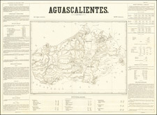
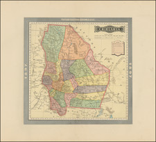
Scarce map of the State of Guanajuato in Mexico, from Garcia y Cubas' monumental Atlas Geographico, Estadistico e Historico de la Republica Mexicana.
Garcia y Cubas was Mexico's first great lithographer, and his work is highly sought after.
This map shows the various regions within the state, towns, roads, rivers, etc. The surrounding text includes a wealth of information regarding Guanajuato, including History, Climate, Agriculture, Minerals, Livestock, Commerce, Population and Itineraries.
Rarity
Only 300 examples of the atlas were reportedly printed, and separate maps rarely appear on the market.
Antonio García y Cubas (1832-1912) was a Mexican geographer, historian, writer, and cartographer. An orphan from a young age, Cubas attended the Colegio de San Gregorio and the Colegio de Ingenieros, where he earned a geography degree. In 1856, he became a member of the Sociedad Mexicana de Geografía y Estadística.
Cubas wrote several geographic works, including introductory courses to geography, historical atlases, and maps. He is best known for his Atlas Geográfico, Estadístico e Histórico de la República Mexicana (1857), Carta General de México (1863), and Diccionario Geográfico, Histórico y Biográfico de los Estados Unidos Mexicanos en cinco volúmenes, editados entre 1888 y 1891. He is also praised for his memoir, El Libro de mis Recuerdos (1905). Today, the best books published in anthropology and history in Mexico are given the Antonio García Cubas prize.