|
||

|

|
|

|
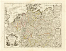
Scarce map of north-central Poland, from Von Reilly's Schauplatz der fünf Theile der Welt.
The map provides a detailed overview of the lower part of the Duchy of Pomerania under Prussian control and the Netze District. This region, extending from just beyond Gmina Chojnice within Chojnice County in the north, down through the Netze District, is characterized by rolling plains, river valleys, and forested areas. Significant cities include Bydgoszcz (Bromberg), a key trade and transportation hub along the Brda and Vistula rivers, and Piła (Schneidemühl), known for its sawmills and lumber industry. Świecie, on the Vistula River, served as an important administrative and economic center, while Chojnice, with its medieval architecture, was a crucial trade and military center. Other notable towns include Nakło and Czarnków, both situated along the Netze River.
The region is defined by several major waterways. The Vistula River flows northward, serving as a crucial trade artery. The Netze River (Noteć), a tributary of the Warta River, is central to the Netze District's waterway system. The Brda River flows through Bydgoszcz, connecting with the Vistula and Netze rivers. Additionally, numerous smaller rivers and lakes dot the landscape, providing rich natural resources and enhancing the region's agricultural productivity. Lakes such as Lake Charzykowskie near Chojnice and other smaller lakes in the area add to the natural beauty and ecological diversity. The region became part of Prussia following the First Partition of Poland in 1772, leading to significant administrative and infrastructural changes. Despite political shifts, the area's cultural heritage, marked by its medieval and Renaissance architecture, was preserved, contributing to its rich historical significance.
Von Reilly's work was issued in multiple volumes and grew to over 1000 maps in total, and was published in three parts between 1789 and 1806 in Vienna.
The work is well regarded for its accuracy and high level of detail of the maps.
![[ Duchy of Warsaw ] Polen im Herzogthum Warschau und unter Oestreich und Russland getheilt](https://storage.googleapis.com/raremaps/img/small/98514.jpg)
![[ Western Poland / South Prussia ] Special Karte von Sudpreussen mit allerhoechster Erlaubniss aus der koniglichen grossen topographischen Vermessungs-Karte, unter Mitwurkung ders Directors Langner, reducirt und herausgegeben vom Geheimen Ober-Bau-Rath Gilly. Die Post-Course und Hauptstrassen sind gezeichnet vom ersten General-Postamts-Registrator Matthias. Gestochen von Carl Jättnig in Berlin . . . 1802 u 1803.](https://storage.googleapis.com/raremaps/img/small/99691.jpg)
![[Wroclaw Plan] A New & Accurate Map of the North East part of Germany, containing the Dominions of the Electors of Saxony & Brandenburg [and] A Plan of the City of Breslaw Capital of Silefia](https://storage.googleapis.com/raremaps/img/small/80094.jpg)
![[Southwestern Poland] Ducatus Oswieczensis et Zatoriensis](https://storage.googleapis.com/raremaps/img/small/67827.jpg)