|
||

|

|
|

|
Stock# 85101
Description
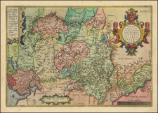
Nice original color-plate engraving showing western Germany, showing the course of the Rhine River from Duisburg to Bonn. The map is orientated with north to the left of the map. This map was first published by Jansson in the 1630s and here reissued by Valk and Schenk at the end of the 17th century.
Cities shown on the map include Duisburg, Dusseldorf, Nuys, Cologne, Bonn, Essen, and Dortmund. The map contains an inset in the upper left of the region around Hamm and Soest. A cartouche and two coats of arms appear at the bottom.
Condition Description
Original hand-color, in outline. Minor soiling.
![[ Brandenburg & Pomerania ] Tabula Electoratus Brandenburgici, Meckelenburgi et Maximae Partis Pomeraniae . . . 1630](https://storage.googleapis.com/raremaps/img/small/99232.jpg)