|
||

|

|
|

|
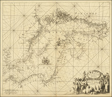
The map Circulus Saxoniae Inferioris Tripartitus: in quo ejus Status atque Principatus exhibentur, offers an intricate depiction of the Lower Saxony Circle, a significant region within the Holy Roman Empire. This map, engraved by Gerard Valk, spans from Oldenborg, Osnabrück, and Paderborn in the west to Stargard, Landsberg, Crossen, and Sagan in the east. It extends from Tönning, Rendsburg, Kiel, Stralsund, and Rostock in the north to Kassel, Göttingen, and Torgau in the south.
The map highlights several major cities, including Berlin, Stettin (Szczecin), Lüneburg, Braunschweig (Brunswick), Magdeburg, Bernburg, Hanover, Bremen, Minden, Hamburg, Wismar, Rostock, and Lübeck. It is a detailed representation of the political and geographical landscape of the region during the late 17th and early 18th centuries.
During the late 17th century, the region encompassing Lower Saxony and its surrounding areas was characterized by significant political and military activity. The Thirty Years' War (1618-1648) had left much of the Holy Roman Empire, including Lower Saxony, in a state of economic and demographic upheaval. The Peace of Westphalia in 1648 marked the end of the war and initiated a period of reconstruction and political reorganization.
The Electorate of Hanover emerged as a dominant power in the region, especially after 1692 when the Duke of Brunswick-Lüneburg was elevated to the status of Elector of Hanover. This elevation significantly increased Hanover's influence within the Holy Roman Empire and beyond.
The early 18th century saw further consolidation of power and territorial adjustments. The War of Spanish Succession (1701-1714) impacted the region as various European powers, including the states within the Lower Saxony Circle, aligned themselves with different factions. The Treaty of Utrecht in 1713 and the subsequent treaties helped stabilize the political landscape.
One of the most notable figures during this period was George I of Great Britain, who ascended to the British throne in 1714 while retaining his title as Elector of Hanover. This personal union between Britain and Hanover significantly influenced the political dynamics of the region.
The map itself, created during this transformative period, reflects the administrative divisions and principalities of Lower Saxony, showcasing the intricate patchwork of territories governed by various dukes, princes, and electors. It serves as a valuable historical document, offering insights into the political geography of the Holy Roman Empire during a time of significant change and development.
Gerard Valk, or Gerrit Leendertsz Valck (1652-1726) together with his son Leonard, were the only significant publishers of globes in the Netherlands in the eighteenth century, enjoying an almost total monopoly in the first half of the 1700's. Initially an engraver and art dealer, and having worked for map-sellers Christopher Browne and David Loggan in London between 1672 and 1679, Valk established the firm in Amsterdam in 1687. Initially, they published maps and atlases, but in 1700 the company moved the shop to the building previously occupied by map and globe-maker Jodocus Hondius. In 1701, he applied for a charter for making globes and the "Planetolabium", designed by Lotharius Zumbach de Coesfelt (1661-1727), an astronomy lecturer at Leiden University. The Valks produced several editions of 3, 6, 9, 12, 15, 18 and 24-inch diameter terrestrial and celestial globes. The cartography, as stated on the cartouche, is based closely on the celestial atlas Uranographia, published in 1687 by the celebrated Polish astronomer Johannes Hevelius (1611-1687).
Around 1711, when he became a member of the bookseller's guild, Leonard Valk (1675-1746) came into partnership and his name started to appear alongside that of his father on the cartouches of the globes, although the earliest of these, both terrestrial and celestial, still bear the date 1700. Leonard naturally took over the business on his father's death in 1726, and following his own death in 1746 the firm was run by Maria Valk, cousin, and wife to Gerard. By then its days of glory had passed. Leonard Valk died in relative poverty: his wife had to take in the washing of their aunt to make ends meet. The late eighteenth century saw a number of successful reissues by publisher Cornelis Covens (1764-1825), who ran the famous cartographical publishing house of Covens & Mortier (1721-1866) in Amsterdam. This firm was the biggest Dutch one for publishing maps in the 18th century. It was located on the Vijgendam (Fig Dam), the southern part of what is now Dam Square, the central hub of the city. They didn't move out of their building, but they did change addresses. At first in 1795 the whole Dam was rebaptized into Revolution Square, then it got the name Napoleon Square, till in 1813 after Napoleon's fall Covens & Mortier were back again at the Vijgendam.
![[Wroclaw Plan] A New & Accurate Map of the North East part of Germany, containing the Dominions of the Electors of Saxony & Brandenburg [and] A Plan of the City of Breslaw Capital of Silefia](https://storage.googleapis.com/raremaps/img/small/80094.jpg)
![[Riga & Environs]. Der Rigische Kreis / Le Cercle de Riga](https://storage.googleapis.com/raremaps/img/small/69148.jpg)