|
||

|

|
|

|
Stock# 75375
Description
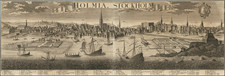
Scarce antique engraved sea chart of the Baltic Sea, embellished by a decorative cartouche, two sailing ships and compass rose.
The map covers the Baltic Sea south of Uusikaupunki ("Nystad"), Finland. St. Petersburg, Stockholm, and Riga ("Ryga") are indicated and labeled.
The cartouche is characteristic of the involved compositions of the Dutch engravers in the latter part of the 17th century. In this case, it shows numerous figures in the local garb of the Baltic.
Originally issued by De Wit, Louis Renard published this map from 1715 to 1739, after which time it was published by Ottens.
Condition Description
A clear, uncolored impression.
![[ Duchy of Warsaw ] Polen im Herzogthum Warschau und unter Oestreich und Russland getheilt](https://storage.googleapis.com/raremaps/img/small/98514.jpg)
![[Swedish Cities] Charta ofver Upstaden Carlstad No. XXXVII [with] Charta ofver Upstaden Christinehamn No. LXVII [with] Charta ofver Bergstaden Philipstad No. LXXIX](https://storage.googleapis.com/raremaps/img/small/70207.jpg)