|
||

|

|
|

|
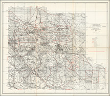
Mapping the Redwood Timber Belt.
Detailed large-format folding map of Humboldt County, California, with its towns of Eureka, Ferndale, and Arcata, lithographed by San Francisco printer Britton & Rey in 1909.
The Redwood timber industry was and still is a major economic driver in Humboldt County, and the present map provides a valuable mapping of the extent of the Redwoods in Humboldt County as of 1909.
Today Humboldt County is part of the Emerald Triangle and is known as a major source of other plant products.
J.N. Lentell's work including maps of Humboldt and Mendocino Counties, as well as a plan of the town of Eureka.
Rarity
The map is quite rare. An 1881, 1898, and 1903 edition are listed in OCLC (one recorded example of each). We previously offered a 1901 edition of the map, which was considerably smaller than this map, previously owned by the ATS&F. Lentell seems to have revised the map in later years, which was republished by Britton & Rey.
We note that the Huntington Library holds a copy of this edition of the map, lacking the original printed covers and with the date given as 1909.