


|
||

|

|
|

|
Full Original Color Example
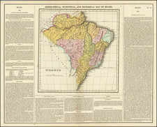
Interesting map of Brazil from the 1814 edition of Matthew Carey's General Atlas. The map shows the territory of Brazil from the mouth of the Amazon to the Rio de la Plata.
The map was published at the midst of the 14 year period (1808-1822) when Brazil was home to the Portuguese Crown and 1 year prior the creation of the United Kingdom of Portugal, Brazil and the Algarves, which raised the status of Brazil from colony to kingdom.
In this detailed and well-executed American-published map, the many rivers, mountain ranges, cities, and islands of Brazil are all shown. Detail extends several hundred miles inland, but the westernmost part of the map is left blank and labeled "Peru."
Fascinating English and Portuguese language annotations appear in the upper portion of the map as well as near the title. These detail the demographics, education system, culture, and more of Brazil.
![[San Salvador / Bahia] Carte Reduite De La Baie De Todos os Santos Et De Ses Atterages Situes a la Cote du Bresil Leve in 1819 dans la Campagne de la Corvette la Bayadere et du Brick le Favory par M.M. Givery et Gressier . . . . . . 1823](https://storage.googleapis.com/raremaps/img/small/62801.jpg)

![A collection of five watercolor drawings from the Luso-Hispanic Border Commission in the Amazon Basin, drawn by its Spanish commanding officer: Parte del camino de tierra de Quito al R. Napo (Lamina I); Vista de la Poblacion y Fortaleza de S. Fran[is]co Xavier de Tabatinga (Lamina V); Vista del Salto grande del Rio Yapurà desde la dist.a de 3 Leguas (Lamina X); Vista del Grande Salto inaccesible del Rio Yapurá (Lamina XI); Los Pongos del Rio Marañon [Lamina XVIII].](https://storage.googleapis.com/raremaps/img/small/100698.jpg)