|
||

|

|
|

|
Art and Evidence: Unique 18th-Century Watercolors of the Deepest Amazon
Drama and Adversity in the Luso-Hispanic Borderlands of Colonial South America
By the Boundary Commissioner In Charge of the Spanish Survey Party
A collection of five stunning and previously unknown watercolors illustrating dramatic scenes from the joint Spanish-Portuguese boundary commission sent to demarcate the frontiers of the Amazon following the 1777 Treaty of San Ildefonso between Portugal and Spain.
These five newly discovered drawings, unsigned but reliably attributed to the officer in command of the Spanish delegation, Francisco Requena y Herrera (1743–1824), Governor of Maynas province, cover events between 1780 and 1783 during the Luso-Hispanic Amazonian surveys. These drawings complement the previously known ten Requena drawings housed in the Oliveira Lima Library in Washington, D.C. The existence of the larger set was first noted by Robert C. Smith in 1946, who described and attributed the drawings; the recent discovery of these additional five drawings substantially extends the series and enhances our understanding of Requena's important and fascinating expedition. Presently, fifteen of the possible eighteen (or maybe more) drawings have been located. Smith (p. 51) noted the Oliveira Lima Library drawings series lacked a drawing showing Requena's party leaving from Quito via the Rio Napo and one showing the Portuguese fort at Tabatinga, which featured prominently in negotiations between the powers; our group includes both of these drawings (Lamina I and Lamina V; see below for a more detailed listing).
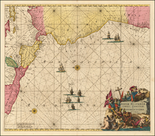
Contested Spanish-Portuguese Frontier in South America
The demarcation of the South American border between the Spanish and Portuguese empires was a complex and evolving process that spanned centuries. The boundary was first defined by Pope Alexander VI in 1493 and then famously revised in 1494 by the Treaty of Tordesillas. Despite these early efforts, the limited geographical knowledge of the 15th century and changing patterns of colonization set the stage for ongoing challenges. It wasn't until the 18th century that the Iberian crowns made significant strides in defining the boundary between Brazil and Spanish South America. This was achieved through key treaties: the 1750 Treaty of Madrid and the 1777 Treaty of San Ildefonso. The latter treaty marked a pivotal step in resolving uncertainties by initiating comprehensive joint Luso-Hispanic boundary surveys. These surveys embarked on an unprecedented exploration of the continent's uncharted terrains, including mountains, rivers, jungles, and savannas. They were staffed with skilled engineers, cartographers, and astronomers, and supported by numerous guides, workers, and soldiers. Spanning several years and thousands of miles, these expeditions were among the most sophisticated and extensive terrestrial mapping endeavors of their time, significantly contributing to the understanding and documentation of the South American interior.
These five drawings derive from the survey stretching from Quito to what is now Tefé, Brazil, which covered the northwestern section of the demarcation line. Spanning from the Andes to the Amazonian jungle, this territory was uniquely perilous and visually striking. It showcased an extraordinary diversity of landscapes, from rugged mountains to dense jungles, along with a rich array of flora and fauna. Additionally, these drawings offer insights into the indigenous cultures of the region, revealing diverse traditions and lifestyles.
Requena the Artist
Unlike many documentary drawings of the period, Requena's watercolors deftly bridge the gap between art and evidence. They exhibit a storyboard or diorama-like quality, redolent of the surrealist jungle scenes of Aloys Zötl and the Amazonian films of Werner Herzog. The illustrative and narrative depth of his artwork goes beyond the draftsman's training Requena received earlier in his career and speaks to a serious eye and creative vision.
Requena was likely trained as a military engineer, requisite preparation for his duties in mapping boundaries in colonial South America in the service of the Spanish crown, but his artistic abilities as revealed in the present highly finished watercolors take him to a different level, akin to the professional artist-topographers sent by France to the far corners of the globe a few decades later, or the artists attached to the U.S. Army's Corps of Topographical Engineers who explored the western frontier in the 19th-century. Requena's official title during his tenure as the Spanish commissioner certainly reflects myriad responsibilities and suggests a man of wide ability: Lieutenant Colonel of Infantry, Regular Army Engineer for Fortresses and Borders, Governor of Maynas, General Commander of his Province and those of Quixos and Macas, First Commissioner of the Fourth Division of Boundaries of His Catholic Majesty.
Requena's qualities as an artist have been effusively praised in the literature:
The detail with which the scenes are rendered, both from the standpoint of the figures and that of the surrounding landscape, gives these Amazonian views a special historical and topographical importance. They abound with precious information about costumes, boats, and architecture, including some little-known Jesuit mission structures. (R. C. Smith, ‘Requena and the Japurá: Some eighteenth-century watercolors of the Amazon and other Rivers’, The Americas, 3:1, 1946, p. 51)
His watercolors are perhaps the only visual records that portray the labors of the boundary commissions... They demonstrate complex sociocultural interactions that go far beyond Luso-Hispanic diplomacy or scientific knowledge. (Jeffrey Erbig, Visual Depictions of Amazonian Boundary Commissions, Olivera Lima Library, Catholic University of America, catalog entry)
The reports and watercolors that Requena produced reveal the day-to-day difficulties that the expedition faced and make clear that their work was far more complex than simply substantiating decisions made in European courts. In affirming that the challenges demanded much of those involved – engineers, astronomers, Indigenous guides, and auxiliaries, among others – Requena presented himself as a zealous official who was able to overcome these obstacles. Requena also emphasized these struggles in his watercolors, with special emphasis on crossing waterfalls. (F. A. Lopes de Carvalho, ‘Mapmaking and Sovereignty Building: Francisco Requena and the Late Eighteenth-Century Boundary Demarcation Commissions’, Hispanic American Historical Review, 102:2, 2022, p. 198)
Afrodescendientes and Native Americans in Requena's Watercolors
The drawings depict firsthand the dynamic interactions of Spanish and Portuguese colonials, Indigenous peoples, and Afrodescendientes. The drawings illustrate the roles in which dozens of Indigenous people were attached to the Spanish boundary expedition, primarily as the muscle needed to carry supplies, tools, and, in some cases (see Lamina I) the colonists themselves. Jeffrey Erbig has identified Fernando Rojas - an erstwhile enslaved man who escaped from Brazil and worked as an interpreter and guide for the Spanish border commission - in the drawings held at CUA. Rojas may appear in our watercolors as well (see Lamina XI). Erbig also points out how independent local people of the tolderias - encampments or settlements of nomadic or semi-nomadic tribes - also played crucial roles as guides during various sections of the boundary survey expedition.
According to Erbig, these exchanges reveal a contradiction of the boundary expedition: neither of the two crowns fully controlled the areas they claimed through demarcation. Indeed, the colonial powers depended on the labor and knowledge of certain Indigenous people, while seemingly acknowledging the sovereignty of other indigenous groups. But one of the implicit objectives of the treaties was to exclude the Indigenous from the system of territorial possession. The Portuguese and the Spaniards as well as missionaries had long relied on the tolderias to access the interior of the region - thus the demarcation of boundaries represented both a continuation of past practices while boding major changes for the future of interethnic politics of both crowns. No matter how much the maps promoted European control - and thus the absence of independent Indigenous people - the present watercolors, by one of the represented colonial powers, fully contradict that vision.
In sum, Requena's watercolors open up a wider story involving the dynamic interactions of Omaguaes (Cambembas) and other indigenous peoples, Afrodescendientes, and Europeans, all grappling within the sometimes unforgiving Amazonian landscape.
The Drawings
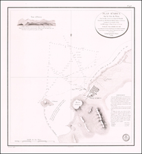
- Lamina I. Parte del Camino de tierra de Quito al R. Napo.
This drawing features an illustration of the Andean land route from Quito to the River Napo traveled by Requena in 1781. Travelers are shown tobogganing down a mountain slope while Indigenous peoples carry Spanish colonials (perhaps including a self-portrait of Requena) as well as their belongings across several makeshift wooden bridges over rapids. The manner of carrying supplies and people (with strap around forehead) is clearly illustrated. Makeshift bridges made of poles and stakes are also shown. Caption in lower margin: A. Modo de llevar los Indios Pasageros, y las cargas. B. Puentes de palos y besucas que se forman an cada entrada. C. Gradas por donde se salvan algunos cerros. - Lamina V. Vista De la Poblacion, y Fortaleza de S. Franco. Xavier de Tabatinga.
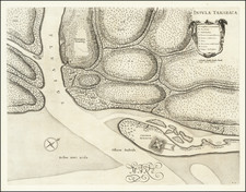
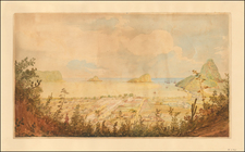
This is one of the illustrations that Smith (p. 51) speculated should exist. It shows the Spanish commander’s xebec (jabeque) in the Rio Marañon, just below the Portuguese fort of Tabatinga firing a salute for the vessels of the Portuguese delegation that arrived there on April 2, 1781. Caption in lower margin: A. Fortaleza. B. Quartel. C. Iglesia. D. Edificio Real. E. Capitana Española que sale al encuentro de la Partida Portuguesa. F. Capitana Portuguesa llegando al Puerto. - Lamina X. Vista del Salto grande del Rio Yapurá, desde la dista. de 3. Leguas.
This and the subsequent drawing illustrate the dramatic landscape and dangerous rapids of the Caquetá-Japurá River during the survey of this tributary in 1782. The present drawing depicts the canyon three leagues from the impassable waterfall which would force the expedition to turn back with members of the party in the foreground shooting monkeys in the trees. Caption in lower margin: A. Salto grande del Yapura, llamado de Vuia, inaccesible y ultimo termino de la Navegacion, que hicieron por este Rio las dos Partidas de la Demarcacion. - Lamina XI. Vista del Grande Salto inaccesible del Rio Yapurá.
This drawing, like the previous one, shows an event from the 1782 survey of the Caquetá-Japurá River. At the base of the Great Japurá Falls a large, dead tree is shown collapsing towards one of the expedition's boats at 2 a.m. causing some of its crew to jump into the river and others in the camp to scatter. A further scene shows members of the expedition, including Spanish colonials and blacks, climbing to the top of the waterfall, with a tiny figure with a telescope at the very top making an astronomical observation. Caption in lower margin: A. Boca del grande Salto del Yapurá. B. Palo que cayó á las dos de la noche causando algunas desgracias en las tripulaciones. C. Subida al monte para examinar el Salto. - [Lamina XVIII.] Los Pongos del Rio Marañon.
This illustration was accompanied by a note that indicated it was "Lamina XVIII". Some early restoration of the drawing, involving laying down of a passe-partout over the margins, seems to have obscured that label. In any event, this likely advances the number of potential drawings by one. This illustration depicts two riverine rafts typical of the Upper Amazon region prominently transporting Requena’s wife and five daughters through the ‘Pongos del Rio Marañón’, most likely the spectacular Pongo de Manseriche, to join Requena at Ega in 1783 where the ailing expedition, much decimated by the desertion, disease, and attacks by the unfriendly Indigenous peoples, had managed to limp back the previous year.
Other Works by Requena
Though apparently not fully digitized, a selection of the Requena drawings at the Catholic University of America can be found here and here.
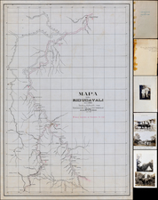
The Library of Congress holds an exceptional group of 10 manuscript maps by Requena.
A lengthy 1797(?) manuscript report which describes one of Requena's maps and may relate to preparations for the boundary expedition, co-authored by Requena and Vicente Aguilar y Jurado, is held by the Archivo Historico Nacional (Spain) and has been digitized here. The text of that manuscript was published in Montevideo in 1846, retaining the original title: Historia de las demarcaciones en la América entre los dominios de España y Portugal, compuesta por Vicente Aguilar y Jurado y Francisco Requena para acompañar al mapa de los países comprendidos en la línea divisoria con arreglo al tratado de 1777.
Provenance
By descent in the family.
Purchased in Barcelona in March 2023.
Spanish export license granted in 2023.
Francisco Requena y Herrera (1743-1824) was a notable Spanish military officer, engineer, geographer, and colonial administrator, renowned for his contributions in the fields of cartography, military engineering, and colonial governance. Born the son of Colonel Francisco de Requena y Molina, he demonstrated an early aptitude in mathematics and engineering, leading to a career that spanned various roles and geographical regions.
Requena's career began at a military academy in his hometown, where his talents in mathematics and engineering were quickly recognized. His skills as an engineer led to his involvement in fortification works in Oran, Rosalcazar, and other locations. He rose through the ranks in the military, being promoted to engineer draughtsman and later to engineer ensign.
In 1764, Requena was assigned to the Audiencia of Panama, where he spent nearly five years working on the fortifications of Panama, Chagres, and Darién. His work as a cartographer began in earnest when he was sent to Guayaquil by the Viceroy of Santa Fe to map the city and fortify its port. His six-year tenure in Guayaquil was marked by significant contributions to the mapping and description of the region, utilizing and building upon the measurements of noted explorers like Bouguer, La Condamine, Jorge Juan, and Antonio de Ulloa.
Requena also played a key role in the division of the bishopric of Quito and was tasked with mapping the district of the Audiencia of Quito. His work extended to the Amazon region, particularly the land of the Omaguas and the governorship of Maynas, where he compiled notes on the old Jesuit missions and later organized the IV Partida de Límites.
His diplomatic and engineering skills were demonstrated in his negotiations with the Portuguese over the surrender of the fortress of Tabatinga and his efforts to resolve territorial disputes between Spain and Portugal in South America following the 1777 Treaty of San Ildefonso. This work culminated in his appointment as a Minister of the Supreme Royal Council of the Indies in 1798 and his involvement in the General Advisory Board for the Defence of both Indies.
Requena's later years saw him rise to the rank of field marshal, and he was involved in various military and engineering projects in Spain, including the canal from Reus to Salou and the defense against Napoleon Bonaparte's invasion. He was also a key figure in the Supreme War Council of Catalonia.
Requena passed away in Madrid at the age of eighty-one, leaving behind a legacy as an exceptional cartographer and a dedicated public servant who played a significant role in the colonial administration and defense of the Spanish Empire in the Americas.