|
||

|

|
|

|
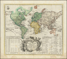
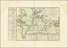
Typus orbis descriptione Ptolemaei is a captivating and decorative world map created by Lorenz Fries in 1522. It beautifully captures Ptolemy's vision of the world as understood in the 2nd century AD surrounded by twelve wind heads symbolizing various wind directions.
The map is a striking exemplar of Ptolemaic cartography, following the principles laid down by Claudius Ptolemy, the renowned Greco-Roman mathematician, astronomer, geographer, and astrologer. His significant book, Geographia, provided the geographical coordinates of the parts of the world known to the Roman Empire during his lifetime. It remained the preeminent printed cartographic reference throughout the second half of the 15th century and into the 16th century.
Ptolemy provided instructions on how to create maps of the whole inhabited world as well as Roman provinces. The map, though only representing about a quarter of the globe, provides invaluable insights into the geographical understanding of his era. Ptolemy improved map projections, enhancing the precision and reliability of cartography at the time.
Lorenz Fries, born in Alsace around 1490, was a trained physician who ventured into cartography. He worked closely with the Strasbourg printer and publisher Johann Grüninger, an associate of the St. Die group of scholars which included Martin Waldseemuller. Fries' map is a continuation of this rich legacy, reflecting the scholarly rigor and the pursuit of geographical understanding in the early 16th century.
Lorenz (Laurent) Fries (ca. 1485-1532) was born in Mulhouse, Alsace. He studied medicine, apparently spending time at the universities of Pavia, Piacenza, Montpellier and Vienna. After completing his education, Fries worked as a physician in several places before settling in Strasbourg in about 1519. While in Strasbourg, Fries met the Strasbourg printer and publisher Johann Grüninger, an associate of the St. Dié group of scholars formed by, among others, Walter Lud, Matthias Ringmann and Martin Waldseemüller.
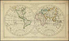
From 1520 to 1525, Fries worked with Grüninger as a cartographic editor, exploiting the corpus of material that Waldseemüller had created. Fries' first venture into mapmaking was in 1520, when he executed a reduction of Martin Waldseemüller's wall map of the world, first published in 1507. While it would appear that Fries was the editor of the map, credit is actually given in the title to Peter Apian. The map, Tipus Orbis Universalis Iuxta Ptolomei Cosmographi Traditionem Et Americ Vespucii Aliorque Lustrationes A Petro Apiano Leysnico Elucubrat. An.o Dni MDXX, was issued in Caius Julius Solinus' Enarrationes, edited by Camers, and published in Vienna in 1520.
Fries’ next project was a new edition of the Geographia of Claudius Ptolemy, which was published by Johann Grüninger in 1522. Fries evidently edited the maps, in most cases simply producing a reduction of the equivalent map from Waldseemüller's 1513 edition of the Geographie Opus Novissima, printed by Johann Schott. Fries also prepared three new maps for the Geographia, of Southeast Asia and the East Indies, China, and the world, but the geography of these derives from Waldseemüller's world map of 1507.
The 1522 edition of Fries' work is very rare, suggesting that the work was not commercially successful. In 1525, an improved edition was issued, with a re-edit of the text by Willibald Pirkheimer, from the notes of Regiomontanus (Johannes Müller von Königsberg).
After Grüninger's death in ca. 1531, the business was continued by his son Christoph, who seems to have sold the materials for the Ptolemy to two Lyon publishers, the brothers Melchior and Gaspar Trechsel, who published a joint edition in 1535, before Gaspar Trechsel published an edition in his own right in 1541.