|
||

|

|
|

|
Stock# 103680
Description
Rare full original hand-color example.
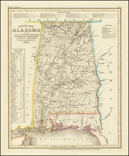
The earliest obtainable large map of Mississippi Territory.
Fine example of this important early map of Mississippi Territory, from the 1814 edition of Matthew Carey's General Atlas.
The map pre-dates the creation of Alabama Territory in 1817 and extends from Georgia to the Mississippi River. The map includes a number of early roads, towns, rivers, Indian tribes, settlements, and more. A number of early forts also appear, including Fort McHenry, Fort Stevens, and Fort Pickering. Many early Indian villages are also named.
An important map for Mississippi and Alabama collectors.
Condition Description
Engraving on 19th-century laid paper. Original hand-color. Some faint offsetting. Minor spotting in blank margins. VG to VG+
![[Florida to New Orleans] The North Coast of the Gulf of Mexico from St. Marks to Galveston . . . 1842](https://storage.googleapis.com/raremaps/img/small/83469.jpg)
![[ Extensively Annotated By An Early Owner ] Georgia from the latest Authorities](https://storage.googleapis.com/raremaps/img/small/100877.jpg)