|
||

|

|
|

|
Stock# 103540
Description
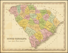
Rare Full Original Hand-Color Version.
Finely colored example of Carey's map of South Carolina, hand-colored by counties, from the 1814 edition of Mathew Carey's General Atlas.
The map provided a large format and highly detailed map of the state, showing towns, roads, rivers, mountains, swamps, counties, meeting houses, and substantial other detail.
One of the earliest obtainable maps of the state of South Carolina.
Condition Description
Engraving on 19th-century laid paper. Original hand-coloring in full. Minor toning at centerfold. Minor spotting and foxing throughout, as shown. VG to VG+
![[ Port Royal, South Carolina ]](https://storage.googleapis.com/raremaps/img/small/81298.jpg)
![The State of South Carolina: from the best Authorities. 1796. [contemporary manuscript annotations]](https://storage.googleapis.com/raremaps/img/small/101052.jpg)