|
||

|

|
|

|
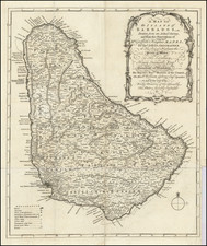
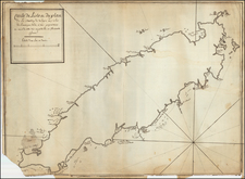
A detailed map of the island of Barbados from Bowen's General Atlas, published in London in 1744.
The map depicts parishes, towns, churches, forts, "Plantations of greatest Note or Sugar Works of three Windmills", "of two Mills", "of one Mill", "Plantations of less Note &c.", and "Rocks under Water."
In the upper right corner is a key listing out the acreage of the parishes of the island, totaling 106,470 acres. The parishes include Christ Church, St. Philip, St. Michael, St. George, St. John, St. James, St. Thomas, St. Joseph, St. Andrew, St. Peter, and St. Lucy.
Emanuel Bowen (1694?-1767) was a British engraver and print seller. He was most well-known for his atlases and county maps. Although he died in poverty, he was widely acknowledged for his expertise and was appointed as mapmaker to both George II of England and Louis XV of France. His business was carried on by his son, Thomas Bowen. He also trained many apprentices, two of whom became prominent mapmakers, Thomas Kitchin and Thomas Jeffreys.