|
||

|

|
|

|
Stock# 103430
Description
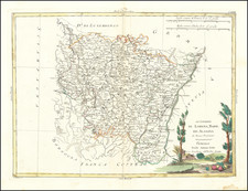
An Important Early Map of Picardy
Rare example of Francois Bougereau's map of Picardy region of France, published in Tours, from his Le Theater Francoys.
The map is centered on the Somme River, extending from its source near Vermandois to the sea.
The map was engraved by Gabriel Tavernier, with his initials (GT) in the lower center of the cartouche.
Picardy part of Hauts-de-France, is an historical region of northern France, stretching north from the suburbs of Paris and vineyards of Champagne to the beaches of the Bay of Somme on the English Channel. The regional capital is Amiens.
Condition Description
Engraving on 16th-century laid paper. Trimmed inside the platemark and remargined on all sides. Some dampstaining.
![[Mâcon] La Ville de Mascon Sur Saone](https://storage.googleapis.com/raremaps/img/small/73814.jpg)
![[Boulogne-sur-Mer] Plan de la Ville de Boulogne](https://storage.googleapis.com/raremaps/img/small/76240.jpg)
![[Nine city views from the Low Countries, including Grevelingen, Ghent, Aat, Winochs-Bergen, Arras, Bethune, and Ypres]](https://storage.googleapis.com/raremaps/img/small/79603.jpg)
![[Boulogne-sur-Mer] Bologna in Francia](https://storage.googleapis.com/raremaps/img/small/61425.jpg)