|
||

|

|
|

|
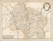
Rare and attractive map by Jean-Baptiste Nolin encompassing the regions of Aunis, Saintonge, and cities like Saint-Jean d'Angély, Marennes, Cognac, and Saintes, capturing the detailed geography between Les Sables d'Olonne, Niort, St.Jean d'Angély, Monguyon, and Cartignac. The central focus is on La Rochelle and its surroundings. Also shown are Oleron and Île de Ré.
The map is richly adorned with marked towns, castles, villages, abbeys, salt pans, and administrative boundaries. A large cartouche in the top right features views of the port cities La Rochelle and Rochefort. On the left margin, there is a significant illustration of the Cordouan lighthouse near the Gironde estuary.
Dating is based on the BnF entry, though it might have been produced in the second half of the 17th century.
Jean-Baptiste Nolin (ca. 1657-1708) was a French engraver who worked at the turn of the eighteenth century. Initially trained by Francois de Poilly, his artistic skills caught the eye of Vincenzo Coronelli when the latter was working in France. Coronelli encouraged the young Nolin to engrave his own maps, which he began to do.
Whereas Nolin was a skilled engraver, he was not an original geographer. He also had a flair for business, adopting monikers like the Geographer to the Duke of Orelans and Engerver to King XIV. He, like many of his contemporaries, borrowed liberally from existing maps. In Nolin’s case, he depended especially on the works of Coronelli and Jean-Nicholas de Tralage, the Sieur de Tillemon. This practice eventually caught Nolin in one of the largest geography scandals of the eighteenth century.
In 1700, Nolin published a large world map which was seen by Claude Delisle, father of the premier mapmaker of his age, Guillaume Delisle. Claude recognized Nolin’s map as being based in part on his son’s work. Guillaume had been working on a manuscript globe for Louis Boucherat, the chancellor of France, with exclusive information about the shape of California and the mouth of the Mississippi River. This information was printed on Nolin’s map. The court ruled in the Delisles’ favor after six years. Nolin had to stop producing that map, but he continued to make others.
Calling Nolin a plagiarist is unfair, as he was engaged in a practice that practically every geographer adopted at the time. Sources were few and copyright laws weak or nonexistent. Nolin’s maps are engraved with considerable skill and are aesthetically engaging.
Nolin’s son, also Jean-Baptiste (1686-1762), continued his father’s business.
![[ Salses-le-Château, France ] Salces en Roussillon.](https://storage.googleapis.com/raremaps/img/small/37766.jpg)

![(Wines of Cognac) Carte des crus du Cognac [Map of Cognac Crus]](https://storage.googleapis.com/raremaps/img/small/89613.jpg)