|
||

|

|
|

|
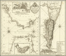
Finely executed sea chart of the Bay of Biscay, first published by Frederick De Wit in 1675.
The map shows the coastline from Bretagne to Biarritz, before turning westward to cover the Basque and Galician coastlines of northern Spain. In the Atlantic Ocean, a fierce naval battle scene is shown. In the top left corner, an inset showing the port of Lorient in Bretegane.
Includes a Latin title in cartouche top right and Dutch title and publisher's imprint in cartouche bottom center
The first state of the map appeared in Frederik De Wit's Atlas de la Navigation (1675), one of the most striking products of Dutch maritime cartography. It was "thoroughly corrected" (Koeman) by Renard in the early eighteenth century and amended again by Ottens in 1745 for their editions of the atlas. Koeman explains, "this continuous revision proves that the atlas was intended for use at sea and not only for the consultation on shore."
The Ottens brothers, Reiner and Joshua, operated a successful printing partnership in the mid-eighteenth century (fl. 1726-1765). They began the venture in 1726, publishing maps and other prints as “R & I Ottens.” They specialized in the reprinting of others’ work, especially Guillaume De L’Isle. In 1750, Reiner died; his soon, also Reiner, took his place, but the firm began listing their works as “Joshua & Reiner Ottens.” The firm lasted until Joshua’s death in 1765. Joshua’s widow, Johanna de Lindt, sold their remaining stock of plates in 1784.
![[ Salses-le-Château, France ] Salces en Roussillon.](https://storage.googleapis.com/raremaps/img/small/37766.jpg)

![[ Basque Harbors ] Kaarte over Pasages Havn / Kaart over Byen St. Sebastian og dens Havn / Kaart over Sudlobet til Bilbao / Havenen ved Santoña](https://storage.googleapis.com/raremaps/img/small/39054se.jpg)