


|
||

|

|
|

|
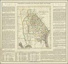
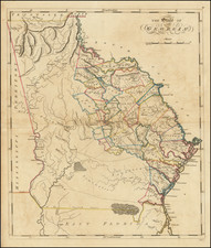
One of the Earliest Obtainable Maps of Georgia in its Modern Configuration.
Full original publisher's color example of Matthew Carey's map of Georgia, the first map of Georgia following its re-configuration in 1812.
This is the second example in full color which we have seen in over 30 years.
Following the creation of Mississippi Territory in 1798, the borders between Mississippi Territory and Georgia were continuously changing, with modifications in 1804 and 1812. Carey's map was the first atlas map published after the establishment of the "modern" boundary between Georgia and Mississippi Territory (which would become the Alabama-Mississippi border).
The map continues to show East Florida to the south of Georgia, with the western 2/3rds of the state still Indian lands, including the Tallassee, Seminole, and various Creek nations still dominating the West, with the area which would become Atlanta still far into the Indian lands.
The map includes a number of early roads, counties, towns, and other features.
An essential map for Georgia collectors.