


|
||

|

|
|

|
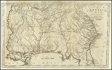
One of the Earliest Obtainable Maps of Georgia in its Modern Configuration.
Attractive example of Matthew Carey's map of Georgia, the first map of Georgia following its re-configuration in 1812.
Following the creation of Mississippi Territory in 1798, the borders between Mississippi Territory and Georgia were continuously changing, with modifications in 1804 and 1812. Carey's map was the first atlas map published after the establishment of the "modern" boundary between Georgia and Mississippi Territory (which would become the Alabama-Mississippi border).
The map continues to show East Florida to the south of Georgia, with the western 2/3rds of the state still Indian lands, including the Tallassee, Seminole, and various Creek nations still dominating the West, with the area which would become Atlanta still far into the Indian lands.
The map includes a number of early roads, counties, towns, and other features.
An essential map for Georgia collectors.
![[ Georgia - Margravate of Azilia ] A Plan representing the Form of Setling the Districts, or County Divisions in the Margravate of Azilia](https://storage.googleapis.com/raremaps/img/small/101398.jpg)

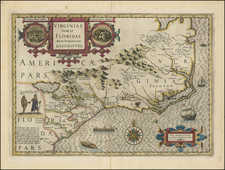
![[ Carolinas & Georgia ] Virginiae Partis australis, et Floridae partis orientalis, interjacentiumqus regionum Nova Descriptio](https://storage.googleapis.com/raremaps/img/small/81554.jpg)