|
||

|

|
|

|
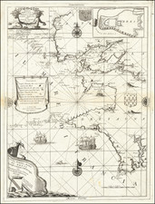
Stock# 103393
Description
Rare chart of the Bay of Biscay, with the Islands of Gurnsey ("Grenesey") and Jersey, as well as adjacent coasts of Normandy and Brittany. An earlier version of the chart was made by Beaurain in 1757.
Joseph Avery, originally from Scotland, gained recognition for mapping the southern coast of England around 1721, producing a map that was widely acclaimed. Later, Avery moved to Charleston, South Carolina, where he pursued a career as a shipbuilder. In 1742, he was appointed as a surveyor for the province of Georgia.
Rarity
The chart is quite rare. We have seen one other example come through the antiquarian market in recent years. OCLC lists only the 1757 edition.
Condition Description
Engraving on 18th-century laid paper. Original hand-color in outline. Some spots and light dampstain, as illustrated.

![(Seven Years' War) [Large contemporary British manuscript plan of the Bay and Battle of Quiberon]](https://storage.googleapis.com/raremaps/img/small/103273.jpg)