


|
||

|

|
|

|
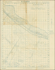
Unrecorded Bigot-Rated Defense Overprint Map of Portbail.
Fantastic Second World War battle map of Portbail, the site of a hard-fought battle between the 7th American Corps and the German army.
Portbail, located on the Cherbourg Peninsula, some 20 miles west of Utah Beach, was one of the key early battles of the Normandy Campaign. The town was a major supply hub for the German army and therefore a key point for Allied attack. American troops reached Portbail on the 18th of June, but the town changed hands multiple times until fighting in the region ceased some three weeks later, on the 6th of July.
The defense information on the map is extensive, even for a Bigot map. Not only are the normal defenses shown, but numerous additional details provide context for the battle. Annotations reveal the multi-layered method of data gathering, with confirmations or changes in older markings. Further, a bridge exiting Portbail is annotated "Bridge Prepared for Demolition."
This is the "stop press" edition of the map, finalized on the 20th of May, 1944, immediately before the D-Day landings. It adds numerous annotations to the earlier May 1944 edition in orange.
Battle of Portbail
In the aftermath of the Normandy landings, the American forces were particularly interested in the town of Portbail due to its role as a German supply point, facilitated by its station and port. Aiming to facilitate the capture of Cherbourg, the Allies, led by the 7th American Corps under General Collins, sought to cut the supply lines and isolate German troops in northern Cotentin. In order to achieve this, Allied aviation bombarded the Portbail sector on June 14, causing significant damage to the village and its infrastructure.
On June 18, the 7th Corps, having crossed the Douve at Sainte-Colombe and Saint-Sauveur-le-Vicomte, pushed its divisions westward. Major General Manton S. Eddy's 9th Infantry Division reached the coastal road from Carteret to La Haye-du-Puits, which was crucial for the evacuation and refueling of isolated German troops. East of Portbail, Colonel George W. Smythe’s 47th Infantry Regiment was relieved by the 357th Infantry Regiment, tasked with holding the frontline.
Despite the American attempts to secure Portbail, German forces managed to evade and launch persistent attacks from the west, causing the Americans to rely heavily on artillery to prevent further encroachments. On June 22, a failed counterattack led to the abandonment of Portbail to the Germans. The situation only stabilized on June 30 when the 315th Infantry Regiment took over the defense. Portbail was finally left in peace on July 6 after the VIII US Corps launched a southward offensive.
The BIGOT classification
The map appears to have been rated "BIGOT TOP SECRET" (identifiable due to the presence of a copy number), which has now been excised in declassification. Introduced during the Second World War, BIGOT was the highest-level military security classification, above Top Secret. Some sources suggest that it was an acronym for “British Invasion of German Occupied Territory;” others, that it was a “backronym” for “To Gib,” the code stamped on the papers of officers headed to Gibraltar in advance of the 1942 North Africa invasion.
Whatever the origins of the term, extraordinary efforts were made to protect BIGOT-level material. When for example a practice landing (“Operation Tiger”) on the Devon coast was ambushed by U-Boats, Eisenhower himself ordered the recovery of the bodies of the ten known victims with BIGOT clearance. This was necessary to prove that they had not been captured alive, as their capture would have compromised the invasion plans and necessitated its cancellation.
Rarity
We were unable to locate any institutional copies of the map through OCLC or related searches. This is the only example of the map that we trace having appeared on the market.
![(Second World War - Prelude - German Irredentism) Die Zerstuckelung Deutschlands. Vom Reiche sollen in Ost und West 5 1/2 Millionen Deutsche getrennt werden! [The Dismemberment of Germany. East and West, 5-1/2 Million Germans Are to be Separated from the Nation] (Large Edition)](https://storage.googleapis.com/raremaps/img/small/94725.jpg)

![Gibraltar to Berlin. [World War II Broadside Map.]](https://storage.googleapis.com/raremaps/img/small/83480.jpg)