


|
||

|

|
|

|
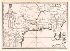
This rare and detailed map, titled "Carte du Canada et de la Louisiane qui forment la Nouvelle France et des colonies angloises," is an exceptional example of Nolin's work, showcasing Canada and the British Colonies with a particular focus on the Great Lakes. Published in Paris by Daumont in 1756, the map captures the territorial claims of France (and a French version of Great Britain's) during the pre-revolutionary period, just before the French and Indian War.
The map provides a wealth of geographical information, with an emphasis on the regions of Canada and Louisiana, as well as the contested lands between French and British territories. It features a meticulous representation of various rivers, lakes, mountains, and settlements, offering valuable insights into the landscape and geography of North America during the 18th century. The map also includes a description of the history and development of Canada and Louisiana, highlighting the discoveries and settlements made by explorers such as Jean Verrazan, Jacques Quartier, and Chavelier de La Salle.
This rare and historically significant map presents a fascinating perspective on the political and territorial struggles between France and Great Britain in the years leading up to the American Revolution.
Jean-Baptiste Nolin (ca. 1657-1708) was a French engraver who worked at the turn of the eighteenth century. Initially trained by Francois de Poilly, his artistic skills caught the eye of Vincenzo Coronelli when the latter was working in France. Coronelli encouraged the young Nolin to engrave his own maps, which he began to do.
Whereas Nolin was a skilled engraver, he was not an original geographer. He also had a flair for business, adopting monikers like the Geographer to the Duke of Orelans and Engerver to King XIV. He, like many of his contemporaries, borrowed liberally from existing maps. In Nolin’s case, he depended especially on the works of Coronelli and Jean-Nicholas de Tralage, the Sieur de Tillemon. This practice eventually caught Nolin in one of the largest geography scandals of the eighteenth century.
In 1700, Nolin published a large world map which was seen by Claude Delisle, father of the premier mapmaker of his age, Guillaume Delisle. Claude recognized Nolin’s map as being based in part on his son’s work. Guillaume had been working on a manuscript globe for Louis Boucherat, the chancellor of France, with exclusive information about the shape of California and the mouth of the Mississippi River. This information was printed on Nolin’s map. The court ruled in the Delisles’ favor after six years. Nolin had to stop producing that map, but he continued to make others.
Calling Nolin a plagiarist is unfair, as he was engaged in a practice that practically every geographer adopted at the time. Sources were few and copyright laws weak or nonexistent. Nolin’s maps are engraved with considerable skill and are aesthetically engaging.
Nolin’s son, also Jean-Baptiste (1686-1762), continued his father’s business.
![(Civil War) Fredericksburg … [with] Map… of the Sioux Expedition [with] Map of the Fight of the 14th A.C. Buzzard Roost, GA [and ] Big Mound [and] Dead Buffalo Lake [and] Dry Fort Creek](https://storage.googleapis.com/raremaps/img/small/97072.jpg)
![[ Missionary Map ] Canada Carte Indiquant Les Limites Des Dioceses, etc. Catholiques Romains Par G. Baillairge Ex-depute-ministre des Treavaux Publics de Canada 1893.](https://storage.googleapis.com/raremaps/img/small/37899.jpg)
![[United States]](https://storage.googleapis.com/raremaps/img/small/93852.jpg)