|
||

|

|
|

|
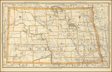
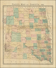
Great Sioux Reservation & Dakota Territory
Rare separately published map of the Dakota Territory, published on March 1, 1886, providing a detailed representation of the Dakota Territory as it existed prior to its division into the states of North and South Dakota.
The map showcases the two general divisions of the territory—South and North Dakota—alongside land districts, Indian reservations, counties, towns, and railroads. The map illustrates counties, cities, towns, railroads, watershed, topography, forts and more. A thin strip of land on the Sioux Indian reservation, between Schnasse County and Dewey and Bozeman Counties is labeled as "not in any county". The Northern & Pacific Railroad bisects North Dakota from Fargo to Sentinel Butte, and identifies many stops along the way, including Bismarck and Mandan.
The Dakota Territory was established by the United States Congress in 1861, encompassing an area that included present-day North and South Dakota as well as parts of Wyoming and Montana. It was a period of significant growth and development, driven by the expansion of the railroads which facilitated the movement of settlers and goods. The construction of the Northern Pacific Railway and other lines through the territory was pivotal for promoting settlement. Towns and cities grew along these rail lines, becoming centers of commerce and community life.
The territory also included the original Great Sioux Reservation, established by the Fort Laramie Treaty of April 29, 1868. Initially, this reservation encompassed all of South Dakota west of the Missouri River. However, by 1886, the year this map was published, the reservation had been reduced in size. The discovery of gold in the Black Hills in the 1870s led to an influx of miners and settlers, eventually resulting in the United States government seizing the land. This act was later recognized by the U.S. Supreme Court as "unfair and dishonorable."
The map indicates the extent of the remaining reservation land and proposed further divisions into smaller reservations, a process that was part of the government's assimilation policies, which included the Dawes Act of 1887. The Act allowed for the division of tribal lands into individual allotments and opened up "surplus" lands to non-Native settlers.
By the time of the map's publication, the Dakota Territory's commissioner, Lauren Dunlap, was involved in promoting the region for settlement, using such maps as a tool to attract immigrants and investors, highlighting the territory's potential for agriculture, ranching, and mining.
The push for statehood was gaining momentum, and by November 2, 1889, the Dakota Territory was split into two states: North Dakota and South Dakota, both admitted to the Union on the same day. This map provides a snapshot of the territorial configuration just a few years before this historic division, capturing the geography and political divisions of the time.
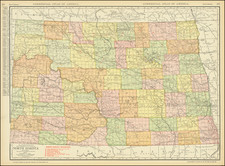
State of the Map & Rarity
There are at least 2 states of the map, one dated September 1st, 1885, and one "Corrected to date of March 1st, 1886."
Both states of the map are very rare. We note an example of the map offered at Old World Auctions in 2008 and the example catalogued by Wright Howes in 1940.
OCLC locates the following examples:
- September 1, 1885: American Antiquarian Society
- March 1, 1886: Huntington Library, Boston Public Library, Massachusetts Historical Society, North Dakota State Historical Society, American Antiquarian Society.
Rand McNally & Co. is a large American map and navigation company best known for its annual atlases. The company got its start in 1856, when William Rand opened a print shop in Chicago. He was joined in 1858 by a new employee, Andrew McNally. Together, the men established their namesake company in 1868. Originally, the company was intended to print the tickets and timetables for the trains running to and through Chicago; their first railway guide was published in 1869.
By 1870, they had shifted from just printing to publishing directories, travel guides, and newspapers. Their first map appeared in 1872 in a railway guide. The map was produced using a new wax engraving method, a cheaper process that gave the company an edge.
By 1880 Rand McNally had entered the education market with globes, wall maps, and geography texts for students. In 1923, Rand McNally published the first Goode’s World Atlas, named after its editor, Dr. J. Paul Goode. For generations afterward, this would be the standard classroom atlas.
In 1899, William Rand left the company, but McNally and his family remained, controlling the company for over a century. In 1904, they published their first road map intended for automobiles and by 1907 were publishing Photo-Auto Guides, which combined photography and mapping to help drivers. In 1924, they produced the Auto Chum, a precursor to their famous road atlases. Rand McNally would remain the leader in road maps and atlases throughout the twentieth century.
In 1937, Rand McNally opened its first store in New York City. Ever on the frontier of technology, Rand McNally pioneered the scribing process for printing tickets in 1958 and printed their first full-color road atlas in 1960. Arthur Robinson developed his now-famous projection of Rand McNally in 1969. By the 1980s, the company was exploring digital reproduction and digital databases of maps for truckers. In the 1990s, they lead the charge to develop trip-planning software and websites. Today, most of its products are available online or in a digital format, including maps for tablets and phones.