


|
||

|

|
|

|
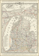
Extremely rare large format separately published map of Michigan, published by George Cram in Chicago.
The map is colored by townships and includes a large inset map of the westernmost portion of the Upper Peninsula.
One of the more unusual features on the map is the meticulous depiction of distances by water across Lake Michigan from Chicago, Milwaukee, Sheboygan and Manitowoc to various points on Michigan's western shoreline.
Rarity
The map is very rare.
OCLC lists only 1 pre-1883 example of this map (1879 example at the Newberry Library), and only 3 other examples between 1883 and 1884 (University of Michigan, Ohio State and Wisconsin Historical Society.
This is the first example we have seen on the market (1992-2024).
George F. Cram (1842-1928), or George Franklin Cram, was an American mapmaker and businessman. During the Civil War, Cram served under General William Tecumseh Sherman and participated in his March to the Sea. His letters of that time are now important sources for historians of the Civil War. In 1867, Cram and his uncle, Rufus Blanchard, began the company known by their names in Evanston, Illinois.
Two years later, Cram became sole proprietor and the company was henceforth known as George F. Cram Co. Specializing in atlases, Cram was one of the first American companies to publish a world atlas. One of their most famous products was the Unrivaled Atlas of the World, in print from the 1880s to the 1950s.
Cram died in 1928, seven years after he had merged the business with that of a customer, E.A. Peterson. The new company still bore Cram’s name. Four years later, the Cram Company began to make globes, a branch of the business that would continue until 2012, when the company ceased to operate. For the final several decades of the company’s existence it was controlled by the Douthit family, who sold it just before the company was shuttered.


![[ Great Lakes - Upper Midwest -- Western Canada ] Partie Occidentale Du Canada, contenant les cinq Grands Lacs, avec Pays Circonvoisons](https://storage.googleapis.com/raremaps/img/small/98377.jpg)