


|
||

|

|
|

|
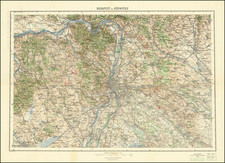
Mid-20th-century map detailing the geographic and infrastructural layout between key Hungarian cities: Budapest, Szeged, Pécs, and Eger. This cartographic artifact provides a meticulous representation of the region's topography, urban areas, and transportation networks during the period.
The map illustrates the varying landscapes of Hungary, from the dense urban sprawl of Budapest, marked by its intricate street grid and the convergence of railway lines, to the more sparsely populated regions towards Szeged and Eger. The representation of Budapest, as the focal urban center, is notably detailed, with the Danube River prominently bisecting the city, reflecting its historical and logistical significance.
Transportation routes, particularly railways and roads, are distinctly marked, demonstrating the vital connections between these urban centers and the surrounding rural areas. These connections underscore the economic and social ties within the region, highlighting the importance of Szeged and Pécs as regional hubs. The detailed depiction of rail and road networks offers insights into mid-20th-century travel and commerce dynamics within Hungary.
The map's topographical elements, including mountain ranges, rivers, and plains, are carefully delineated, providing a comprehensive understanding of the region's physical geography. This topographical detail not only aids navigation but also contributes to a broader understanding of the environmental and agricultural characteristics of the area.
The color scheme and symbology used in the map are indicative of the cartographic standards of the mid-20th century, providing clarity and a wealth of information at a glance. Different colors and symbols distinguish between types of terrain, urban areas, bodies of water, and transportation routes, facilitating easy navigation and interpretation.
![[ Holy Roman Empire ] S. Imperium Romano-Germanicum oder Teutschlenad mit Seinen Angrantzenden Konigreichen und Provincien,...](https://storage.googleapis.com/raremaps/img/small/98433.jpg)

![[ Austro-Hungary ] Germany. Austrian Dominions](https://storage.googleapis.com/raremaps/img/small/102014.jpg)
![[Eastern Hungary / Western Romania] Partis Hungariae Inter Tibiscum et Nigrum Chrysum. Nova et Accurata Descriptio](https://storage.googleapis.com/raremaps/img/small/91370.jpg)
![[ Budapest ] Plan de la Ville et des Attaques de Bude. en 1686](https://storage.googleapis.com/raremaps/img/small/86460.jpg)