


|
||

|

|
|

|
The Empire of Austria
The map titled “Germany, Austrian Dominions,” published by Lizars around 1840, is a detailed cartographic representation of a considerable portion of Central and Southeastern Europe. By the early 19th century, the art of mapmaking had reached new heights, with detailed depictions of geographical features and political boundaries. This map, in particular, sheds light on the vast dominions under the banner of the Austrian Empire. Given the detailed nature of this map, with indications of cities, roads, rivers, mountains, and lakes, it serves as a testament to the meticulous nature of cartographers in this period.
Regions and Their Histories in the First Half of the 19th Century
- Austria: The heart of the Habsburg Empire, with Vienna as its capital. Under the leadership of Emperor Francis I (reigned from 1804-1835) and later his son, Ferdinand I, Austria saw the rise of nationalism and demands for constitutional reforms.
- Bohemia and Moravia: Primarily Czech regions with Prague as the capital of Bohemia. Both territories witnessed increased demands for autonomy from the Habsburg Empire.
- Galicia: A region with a Polish majority and Ukrainian minority. Lemberg (modern-day Lviv) was its capital. The period saw a growing Polish nationalism against Austrian rule.
- Tyrol and Salzburg: Alpine regions with Innsbruck as Tyrol's capital. The early 19th century witnessed anti-Napoleonic sentiments and uprisings.
- Styria, Carinthia, and Lombardy: Graz is the capital of Styria. These regions experienced tensions as Napoleonic wars reshaped their borders and governance.
- Croatia, Istria, and Dalmatia: Zagreb is the capital of Croatia. These regions saw rising Croatian nationalism and struggles against both Austrian and Hungarian influences.
- Hungary: Budapest as its capital and under the leadership of Palatine Joseph, Hungary was in a constant struggle for greater autonomy from the Habsburgs.
- Sclavonia, Bannat, Transylvania, and Bukovina: Varied regions with Timişoara as the capital of Bannat and Cluj as the capital of Transylvania. These regions, particularly Transylvania, witnessed tensions among Romanians, Hungarians, and Saxons.
- Silesia: A region primarily in modern-day Poland with Breslau as its capital. It experienced industrial growth and was a bone of contention between Austria and Prussia.
Overview of Political History
The initial decades of the 19th century for the Austrian Empire were akin to navigating a ship through stormy seas. The aftershocks of the Napoleonic Wars and the defining Congress of Vienna (1815) left Austria as one of Europe's principal powers, but it was an empire simmering with internal discontent.
The Empire’s tapestry of ethnicities witnessed a surge in nationalism, with each thread vying for more autonomy. The Metternich system, championed by State Chancellor Prince Klemens von Metternich, sought to suppress these rising liberal and nationalist voices. The pressures built up, and by the 1840s, the Empire stood at the threshold of the sweeping Revolutions of 1848.
In summation, Lizars’ map paints more than just the physical terrain of the Austrian Empire; it encapsulates the diverse and multifaceted nature of an empire at its zenith, yet on the precipice of profound internal change. The regions, with their unique identities, set the stage for the dynamic transformations that the latter part of the century would usher in.
The Lizars were a Scottish family of engravers and printers who produced many views and maps. Daniel Lizars Sr. (1754-1812) was the son of a shoemaker, but he apprenticed with Andrew Bell, a printer and engraver. Lizars set up his own printworks near St. Giles Cathedral and took on his own apprentices, including George Bartholomew, whose son John would go on to found the important mapmaking firm later know as John Bartholomew & Son Ltd.
Daniel Sr. had three sons: Daniel Jr., John, and William Home. He also had a daughter, Jane Home. Daniel Jr. (1793-1875), the youngest of the boys, apprenticed in his father’s shop alongside George Bartholomew. When his father died in 1812, Daniel Jr. took over much of the business, expanding it and specializing in maps. The company went bankrupt in 1832, however, and Daniel emigrated to Canada.
John Lizars (1792-1860), the middle son, studied medicine and became Professor of Surgery at the Royal College of Surgeons of Edinburgh, as well as senior surgeon at the Royal Infirmary of Edinburgh.
William Home Lizars (1788-1859), the eldest, also apprenticed in his father’s shop. After learning engraving, William entered the Trustees’ Academy to learn under John Graham. He was a skilled painter and artist. When his father died, and after his Daniel Jr. left, he carried on printing and invented a method of etching that looks like wood engraving.
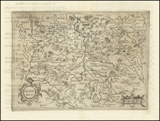
![[ Istria, Sloveniam, Northern Croatia ] Karstia, Carniola Histria et Windorum Marchia](https://storage.googleapis.com/raremaps/img/small/95562.jpg)
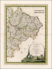
![Bohemia In Suas Partes Geographice Distincta Petrus Kaerius Caelavit (Carte-a-figures edition) [Bohemia Divided Into Its Geographic Parts, Engraved by Peterus Kaerius]](https://storage.googleapis.com/raremaps/img/small/80057.jpg)