|
||

|

|
|

|
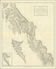
An Exceptional Fraser Canyon Gold Rush Rarity
The second known example of the 1859 edition of this remarkable early map of the Pacific Northwest, covering Washington Territory and British Columbia, with information derived from the Hudson Bay Company and Royal Engineers surveying activity in the region.
The Fraser Gold Rush had begun in 1858 and cartographic information was somewhat slow to make its way back to London. Thus, this is one of the earliest and best maps for the region from this crucial era. The map extends from the Columbia River in the south and east to upper tributaries of the Fraser River in the North.
As is declared in the title, the focal point of the map are the gold discoveries on the Fraser River and Washington Territory, with extensive Gold Regions and "Indian Diggings" noted on either side of the Fraser River from the Queensborough area north to the edge of the map near Chilcotin River and on either side of Thompson's River, Lake Kenloop and Lake Shuswap. Additional coarse goad regions are noted in the uppermost part of the Columbia River, in British Columbia.
Gold Regions in Washington Territory
One of the map's noteworthy features is the numerous areas shown as gold diggings in Washington Territory.
- To the east of Seattle, Cedar River and Nooskope River are shown as gold regions.
- East of the Cascade Mountains, a "Rich Gold District" is shown on the upper forks of the Yakima River and in the pass to the east of Snoqualmie River.
- Northeast of Seattle, the area at the confluence of the Culcum River and Scatchet River is shown as a gold region.
While largely a product of Fraser River Fever, the map certainly encourages the notion of gold in Washington Territory. Gold was first discovered in 1853 in the Yakima River Valley by a party under the command of Capt. George McClelland exploring a possible railroad route. By 1855, prospectors were active in the Colville district although the first discoveries were not made until 1883. In 1855, small placers were found along the Columbia and Pend Oreille Rivers. From the 1850s through the 1880s, placers were worked along streams in Okanogan, Whatcom, Chelan, and Kittitas Counties and along the major streams of the State - the Columbia and Snake Rivers.
States of the Map
There are two states of the map, differentiated only by the datings (August 9, 1858 and August 9, 1859).
As noted below, this is apparently the second known example of the 1859 state.
Rarity
Both states of the map are very rare, with the last example appearing on the market approximately 40 years ago.
We note institutional examples at:
- 1858: University of Victoria (BC), California State Library and British Library.
- 1859: University of British Columbia (misdated 1858).
RBH lists only the Streeter Copy (#3420), which sold for $150 in 1969.
AMPR lists 2 copies of the 1858 edition (Old Maps & Prints in 1982 and Robert Downma Ltd in 1984, priced at about $1,154).
James Wyld Sr. (1790-1836) was a British cartographer and one of Europe’s leading mapmakers. He made many contributions to cartography, including the introduction of lithography into map printing in 1812.
William Faden, another celebrated cartographer, passed down his mapmaking business to Wyld in 1823. The quality and quantity of Faden’s maps, combined with Wyld’s considerable skill, brought Wyld great prestige.
Wyld was named geographer to Kings George IV and William IV, as well as HRH the Duke of York. In 1825, he was elected an Associate of the Institution of Civil Engineers. He was one of the founding members of the Royal Geographical Society in 1830. Also in 1830, his son, James Wyld Jr., took over his publishing house. Wyld Sr. died of overwork on October 14, 1836.
James Wyld Jr. (1812-87) was a renowned cartographer in his own right and he successfully carried on his father’s business. He gained the title of Geographer to the Queen and H.R.H. Prince Albert. Punch (1850) described him in humorous cartographic terms, “If Mr. Wyld’s brain should be ever discovered (we will be bound he has a Map of it inside his hat), we should like to have a peep at it, for we have a suspicion that the two hemispheres must be printed, varnished, and glazed, exactly like a pair of globes.”

![[ Pacific Coast Pictorial Road Maps ] Scenic Touring Scout](https://storage.googleapis.com/raremaps/img/small/101745.jpg)