|
||

|

|
|

|
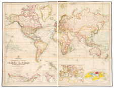
First Edition of The Official World Map Encompassing Cook's Three Voyages.
Highly detailed map of the World on Mercator's Projection, identifying the routes of Captain James Cook's three voyages aboard the Endeavor (1768-1771) and Resolution (1772-1780).
Drawn by Lt. Roberts, who accompanied Cook on his voyages, the map provides a detailed, large format account of Cook's 3 expeditions, includes dates and the many places where Cook coasted and landed during his 12 years at sea. There are also notes from several other major discoveries in Australia and the South Pacific and annotations, providing details of the voyages and the history of the discovery of certain regions.
Engraved by Palmer in London, this map accompanied the official account of Cook's Voyages.
Henry Roberts and the publication of the charts of Cook’s third voyage
Henry Roberts served on the Resolution during Cook’s second voyage as an Able Seaman. He proved to have a knack for drawing charts and coastal views and served as a draughtsman throughout the voyage. Roberts returned as master’s mate on the Resolution for the third voyage, when he again was tasked with preparing maps, charts, and views.
Upon returning to England, Roberts was made lieutenant and asked to prepare the charts for the official voyage account of the third voyage, which was being edited by James King and Canon John Douglas. Many of the maps had already been drawn while at sea, including this general chart, but then were further revised on land. Of this chart, Roberts wrote in a letter of May 15, 1784:
Soon after our departure from England, I was intrusted by Captain Cook to complete a map of the world as a general chart, from the best materials he was in possession of for that purpose; and before his death this business was in a great measure accomplished; That is, the grand outline of the whole was arranged, leaving only those parts vacant or unfinished, which he expected to fall in with and explore. But on our return home, when the fruits of our voyage were ordered by the Lords Commissioners of the Admiralty to be published, the care of the general chart being consigned to me, I was directed to prepare it from the latest and best authorities; and also to introduce Captain Cook’s three successive tracks, that all his discoveries, and the different routes he had taken might appear together, by this means to give a general idea of the whole. This task having been performed by me, it is necessary, for the information of the Reader, to state the heads of the several authorities which I have followed in such parts of the chart as differ from what was drawn up immediately under the inspection of Captain Cook and when the Public are made acquainted, that many materials, necessary to complete and elucidate the work, were not, at the time, on board the Resolution, or in his possession, the reason will appear very obvious, why these alterations and additions were introduced contrary to the original drawing.
Roberts’ appointment annoyed William Bligh, who has also served on the voyage, performed many of the original surveys, and had worked closely with Roberts on the manuscript draughts. Roberts’ slow pace of work exasperated others, including John King, Joseph Banks, and Alexander Dalrymple. The voyage account’s maps and charts were finally ready in 1784, when the work was published by the Strahans and Cadell.
![[ The Lost Paulus Ageminius Casket Map ]](https://storage.googleapis.com/raremaps/img/small/97534.jpg)
![[From the Library of Captain Louis Freycinet] Carte Hydrographique Des Partes Connues De La Terre Dressee sur la Projection de Mercator, Poar C.LO. Gressier , Ingenieur Hydrographe de la Marine . . . 1835 (with extensive manuscript annotations)](https://storage.googleapis.com/raremaps/img/small/58604.jpg)