This item has been sold, but you can enter your email address to be notified if another example becomes available.


|
||

|

|
|

|
Stock# 103245
Description
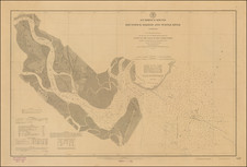
Rare separately published map of the region between the Tennessee River and the Atlantic Ocean.
The map was 1 of 4 sheets compiled as part a US Military project showing the locations of works and surveys for river and harbor improvement, compiled for the Index to the Reports of the Chief of Engineers under the direction of Henry M. Robert, Major of Engineers, U.S.A., 1879
The map notes "Transportion Routes To The Seaboard Southern Route From The Mississippi River To The Atlantic Ocean By Way of the Tennessee River, with this sheet showing the route from the Tennessee River to the the area around Darien, Georgia.
Rarity
The map is very rare -- we note only the example in the collection of the New York Public Library.
Condition Description
Minor dampstain
![[Alabama, Mississippi, Arkansas, Louisiana and part of Tennessee and Western Florida] Amer. Sep. No. 56 Partie des États Unis](https://storage.googleapis.com/raremaps/img/small/93538.jpg)