


|
||

|

|
|

|
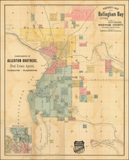
Map of the City of Spokane Falls, Washington, published during the height of Spokane's major boom period following the arrival of the Northern Pacific Railroad and Great Northern Railway to Spokane.
The growth of Spokane during the 16 year period after the Great Fire of 1889 is clearly in evidence, when compared to Whitney's Map of the City of Spokane Falls and Environs. Washington, 1890. Between 1900 and 1910, the population of Spokane would triple as it became an important regional commercial and transit hub.
The area which had become Spokane's Chinatown, between Howard and Bernard, is part of the "Resurvey and Add. To Spokane Falls."
Spokane
Beginning in the 1830s and 1840s, American settlers began coming to the then Oregon Country by the Oregon Trail. The first American settlers, squatters in the Spokane area, J.J. Downing and S.R. Scranton, built a cabin and established a claim at Spokane Falls in 1871. Together they built a small sawmill on a claim near the south bank of the Spokane Falls. James N. Glover and Jasper Matheney, Oregonians passing through the region in 1873, recognized the value of the Spokane River and its falls. They bought the claims of 160 acres and the sawmill from Downing and Scranton for a total of $4,000. Glover and Matheney knew that the Northern Pacific Railroad Company had received a government charter to build a main line across this northern route. Glover later became known as the "Father of Spokane".
In 1880, Fort Spokane was established by U.S. Army troops under Lt. Col. Henry Clay Merriam 56 miles northwest of Spokane at the junction of the Columbia and Spokane Rivers to protect the construction of the Northern Pacific Railway and secure a place for U.S. settlement. By 1881, the Northern Pacific Railway was completed, bringing major European settlement to the area. The city of Spokan Falls (the "e" was added in 1883 and "Falls" dropped in 1891) was officially incorporated as a city of about 1,000 residents on November 29, 1881.
The city's population ballooned to 19,922 in 1890, and 36,848 in 1900 with the arrival of the railroads. After the 1883 discovery of gold, silver, and lead in the in the Coeur d'Alene region of northern Idaho, this precipitated a rush of prospectors into the region. The Inland Empire erupted with numerous mining rushes from 1883 to the late 19th century. Mining emerged as a major stimulus to Spokane. At the onset of the initial 1883 gold rush near Coeur d'Alene, Spokane became the outfitter of choice among prospectors due to the area's proximity, lower prices, and convenience of being able to obtain everything "from a horse to a frying pan". It would keep this status for subsequent rushes in the region due to its' trade center status and accessibility to railroad infrastructure.
Spokane's growth continued unabated until August 4, 1889, when a fire, now known as The Great Fire, destroyed the city's downtown commercial district. After The Great Fire of 1889 and the rebuilding of the downtown, the city was reincorporated under the present name of "Spokane" in 1891. Just three years after the fire, in 1892, James J. Hill's Great Northern Railway had arrived in the newly created township of Hillyard (annexed by Spokane in 1924)-the chosen site for Hill's rail yards. The railroads in Spokane made it a transportation hub for the Inland Northwest region.
Starting in 1890, Francis H. Cook initiated the Spokane and Montrose Street Railway, forming the foundation of what would become the Spokane and Inland Empire Railroad Company. This was sold to Jay P. Graves' group in 1902, leading to the formation of the Spokane Traction Company in 1903 and its reconstitution as the Spokane and Inland Empire Railroad Company in 1904. This entity extended its routes throughout Spokane, affecting areas like Corbin Park, Hillyard, and Lincoln Heights.
Spokane transformed into a critical commercial and rail hub of the Inland Northwest, positioned strategically among significant geographic and industrial zones, amplified by its location at the crossroads of four transcontinental railroads. By 1900, the population had escalated to 36,848 due to railroad-driven immigration from regions as diverse as Finland, Germany, England, Minnesota, and the Dakotas, attracted by promotional campaigns touting "Spokane Country."
Additionally, a substantial Asian community formed in an area known as Chinatown, evolving from a transient labor camp primarily for Chinese workers into a more stable community, particularly with the influx of Japanese families around 1900. This area, initially marred by a negative reputation, improved significantly as more families settled, contributing to cultural diversity and establishing places of worship like the First German Baptist Church in East Central.
By 1910, Spokane's population soared to 104,000, bolstered by the expanding railroad connections to major commerce centers in the east, west, and Canada, surpassing Walla Walla as the region’s commercial nucleus. Consequently, Spokane emerged as the "capital" of the Inland Empire, central to the region's extensive tributary network.
George F. Cram (1842-1928), or George Franklin Cram, was an American mapmaker and businessman. During the Civil War, Cram served under General William Tecumseh Sherman and participated in his March to the Sea. His letters of that time are now important sources for historians of the Civil War. In 1867, Cram and his uncle, Rufus Blanchard, began the company known by their names in Evanston, Illinois.
Two years later, Cram became sole proprietor and the company was henceforth known as George F. Cram Co. Specializing in atlases, Cram was one of the first American companies to publish a world atlas. One of their most famous products was the Unrivaled Atlas of the World, in print from the 1880s to the 1950s.
Cram died in 1928, seven years after he had merged the business with that of a customer, E.A. Peterson. The new company still bore Cram’s name. Four years later, the Cram Company began to make globes, a branch of the business that would continue until 2012, when the company ceased to operate. For the final several decades of the company’s existence it was controlled by the Douthit family, who sold it just before the company was shuttered.
![[Washington Territory]](https://storage.googleapis.com/raremaps/img/small/85513.jpg)
![Pacific Coast Highways Canada to Mexico [Texaco Tour Maps Routes and Mileages Canada to Mexico]](https://storage.googleapis.com/raremaps/img/small/91594.jpg)