|
||

|

|
|

|
Stock# 102965
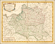
Description
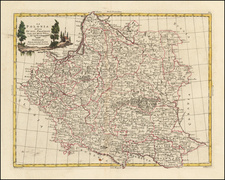
Curious map the region bounded by the North Sea and Baltic, and showing towns, provinces, states, roads, rivers, etc.
Unusual two sheet format, with the left sheet being a much smaller sheet which has been added to extend the map in the west.
Apparently, the two different paper qualities have aged differently.
An interesting and scarce map from this well regarded Viennese publisher.
Condition Description
Engraving on two sheets of 18th-century paper joined as one Original hand-color in outline. Left sheet aged differently. Some minor spotting and foxing on right sheet as shown.
![[ Scandinavia ] Tabula Geographica Regnorum Sueciae Daniae et Norwegiae](https://storage.googleapis.com/raremaps/img/small/102797.jpg)