


|
||

|

|
|

|
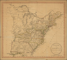
Scarce first edition of Vivien's map of the United States, ten years prior to Texas' Independence.
The treatment of the oversized 54-40 or fight Oregon Territory, Missouri Territory and the region west of the Mississippi is especially interesting. Most notable are the Spanish names appearing along the western porion of the Southern Mississippi River for the regions which would become Missouri and Arkansas and Missouri, including Lawrence, Cape Girardeau, Howard and St. Louis. These names of districts derived originally under French and later Spanish control of the Louisiana Territory. The appearance of Howard District is especially unusual.
The map is rich with tribal names, far more than typical. This is especially true in the Northwest and may be a result of recent dissemination of the account of Hunt & Stuart which had only recently been translated into French. This text, called the Nouvelle Annales des Voyages, is the only contemporary account of their trip to and from Astoria, which resulted in the discovery of the South Pass and the first use of what would become the Oregon Trail. A striking map from a fascinating time period in American history.

![[ Promoting Emigration To The Czech Market ] Ceske Osady V Americe [ A Correct Map of the United States of America Showing Atchison, Topeka and Santa Fe R.R. and Connections ]](https://storage.googleapis.com/raremaps/img/small/101348.jpg)
![[1958 World's Fair] The United States The Land of the People / Les Etats-Unis Le Pays et ses Habitants / De Verenigde Staten hed Land en het Volk](https://storage.googleapis.com/raremaps/img/small/76701.jpg)