|
||

|

|
|

|
Stock# 102798
Description
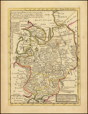
Detailed map of the Kiev Region, bounded by the Dniepr on the east and with the City of Kiev centered.
Shows rivers, roads, towns, castles, forests, lakes and a host of other details.
From Von Reilly's exceedingly scarce Grosser Deutscher Atlas.
Von Reilley & Schaembl led a revival of map making in Vienna in the late 18th Century which included this and several other sought after works.
Condition Description
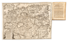
Hand-coloring on 18th-century paper. Minor damp staining as shown. Minor foxing.
![(Second World War - Eastern Front) [Strikes by the Red Army on the Enemy in 1944] Удары Красной Армии По Противнику в 1944г.](https://storage.googleapis.com/raremaps/img/small/68414.jpg)
![(Anti-Nato Propaganda) Военные Блоки-Оплот Милитаризма [Military Blocs-Strongholds of Imperialism]](https://storage.googleapis.com/raremaps/img/small/94274.jpg)