|
||

|

|
|

|
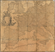
Extremely rare Red Army-published map of the progress of the Second World War on the Eastern Front during 1944.
The map shows the extensive gains of the U.S.S.R. throughout late 1943 and 1944, from their nadir, with the Germans at the outskirts of Moscow in 1943, to the assaults on Warsaw and Budapest in November of 1944.
The map was published by the Topographic Department of the "N-Section Armies" ("Составлено и Издано Топо Отделом N-ской Армии.") We have been able to find out precious little about this designation in our initial research, besides a suggestion that it possibly denoted Northern Front armies at Leningrad. We would welcome any additional information on these units if it is available.
The map highlights the shortage of paper on the Eastern Front during this period, as the map was printed on a repurposed 1939 Red Army General Staff map of the area between Prague and Dessau including Leipzig and Dresden.
At one time the map was probably accompanied by a key relating to the numbers given on the map, though we cannot find another example of the map to test this theory.
Key
Граница Территории Оккупированной Немцами [The border of the territory occupied by the Germans]
Линия Фронта На 5.7.43г. [Front Line on 5.7.43]
Линия Фронта На 7.11.43г. [Front line on 7.11.43]
Линия Фронта На 22.6.44. [Front line on 22.6.44]
Линия Фронта На 7.11.44г. [Front line on 7.11.44]
Линия Фронта Союзников [Allied front line]
![[European Russia] Гидрографическая Карта Европейской Россіи. Составлена Департаментом Проэентовъ И Смѣтъ Главнаго Управления Путей Сообщения и Публичныхъ Зданій | Hydrographical Chart of European Russia Compiled by the Project and Estimate Department of the Chief Direction of Ways of Communication & Public Buildings 1846.](https://storage.googleapis.com/raremaps/img/small/61005.jpg)