|
||

|

|
|

|
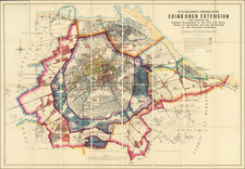
The Growth of Edinburgh - 1685 to 1896 -- Not in OCLC!
Rare and extraordinarily detailed historical map of Edinburgh, highlighting its growth from the "Ancient Royalty" (1685) to its modern configuration in 1896.
The Edinburgh Extension map of 1896 delineates the momentous expansion of Edinburgh’s municipal boundaries at the turn of the 20th century, highlighting the transition from medieval cityscape to modern urban form. It portrays not only the present and proposed extensions of the city but also integrates the historical annexations with a vivid chromatic scheme, providing a unique visual narrative of Edinburgh's urban development.
In the late 19th century, Edinburgh was undergoing significant transformations, reflecting broader urban trends across Britain. The city, famous for its historic and picturesque landscapes, was grappling with the challenges of industrialization and a rapidly growing population. The Edinburgh Extension map captures this pivotal moment, representing the city’s ambition to modernize and accommodate its expanding populace. By delineating the boundaries of proposed extensions, it encapsulates the urban planning ideologies of the time, aimed at improving living conditions, integrating surrounding parishes, and facilitating economic growth.
The map illustrates the history of Edinburgh's borders, noting changes from 1685, 1736, 1767, 1809,1832, 1848, 1854, 1856, 1882, 1885 and 1890.
- The Present Boundaries of Edinburgh are indicated with a specific color.
- The Boundaries of the Proposed Extension (to Edinburgh) are shown in a different distinct color.
- The Boundaries of the Burgh of Leith are marked with their unique color representation.
- The Boundaries of the Burgh of Portobello are also shown with a distinct color.
- Dark Blue Color denotes areas covered with Buildings or Feued within Districts that were annexed to Edinburgh in the years 1882, 1885, and 1890.
- Brown Color represents areas covered with Buildings or Feued in County proposed to be annexed.
- The map also includes symbols for Tramways and Roads, each represented by specific styles of lines and colors.
This legend aids in understanding the expansion and urban development of Edinburgh at the end of the 19th century, illustrating the city’s annexation efforts and proposed growth areas.
The map divides Edinburgh into distinct sections using color-coded boundaries to distinguish between the existing city limits, proposed expansions, and surrounding boroughs such as Leith and Portobello. Notably, it employs a palette of colors to differentiate between areas, with specific hues representing different jurisdictions and land uses, thereby providing clarity and enhancing the map's utility as a planning tool. The clear demarcation of tramways and roads further exemplifies the city’s infrastructural development and reflects contemporary advancements in public transportation and urban planning.
Rarity
The map is extremely rare.
We locate no examples in OCLC.
The map is listed in Sir Arthur Mitchell and Caleb George Cash's A Contribution to the Bibliography of Scottish Topography, p. 591 (1917) (Scottish History Society publication).
![[Scotland] Scotiae Tabula](https://storage.googleapis.com/raremaps/img/small/35612.jpg)
![[ Scotland ] Magnae Britanniae Pars Septentrionalis qua Regnum Scotiae . . .](https://storage.googleapis.com/raremaps/img/small/89707.jpg)