|
||

|

|
|

|
Detailed postal map of London, specifically crafted and engraved for the Post Office in the year 1904. This map was produced for inclusion in Kelly's Directories, known for their comprehensive listings and guides to various areas of the United Kingdom, providing valuable historical insight into London's postal regions, transportation networks, and topography at the turn of the 20th century.
The map includes details such as the "Postal Boundary" and "Underground Railways," making it a functional tool for understanding the extent of postal districts and the then-emerging underground transportation system. The map notes " . . .the elevation above the sea level," providing additional utility for postal route planning and general navigation within the urban landscape.
This 1904 postal map of London stands as a significant artifact, offering a window into the early 20th-century urban and postal history of the city.
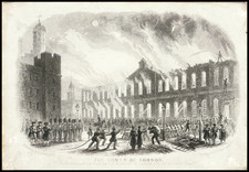
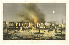
![The Tower of London, As Seen October 31st 1841 [the morning after the fire]](https://storage.googleapis.com/raremaps/img/small/92003.jpg)
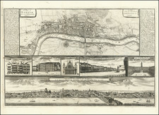
![[London] Londres](https://storage.googleapis.com/raremaps/img/small/85152.jpg)