


|
||

|

|
|

|
Stock# 102584
Description
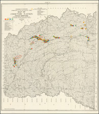
Oil in the Oklahoma Panhandle
Detailed map of the oil drilling activities in Cimmaron County, Oklahoma.
We date the map based in large part on the short-lived activities of the Ramsey Brothers in Cimmaron County (approximately 1925 to 1930).
The map is extensively coded to show the following information.
First List: Drilling and Company Blocks
- Sinclair Oil & Gas Company block, Rotary Drill 1500 feet
- J. R. Phillips block, Drilling at 1700 feet
- Ramsey Brothers block, Well no. 1, Oil at 4095 feet, now drilling below 4150 feet. Well No. 2, drilling at 1800 feet
- M. M. Valerius and Gladys-Belle Co. block, drilling at 2000 feet
- Smith-Krull block, Derrick blown down
- Reiter-Foster block
- Marland Oil Company blocks
- State School Land Leases awarded F. F. Gillam
- Ramsey Bros block, State School Land
- J. W. Alford Co. block
- McNabb block
Second List: Lease Colors and Owners
- Green: Sinclair Leases
- Red: W. E. and W. R. Ramsey Leases
- Purple: Amerada Petroleum Corp., Leases
- Blue: Magnolia Oil Company Leases
- Brown: Wentz Leases
- Orange: Marland Oil & Gas Co., Leases
- Tan: Covers the holdings of Texas Oil Co., Indian Territory Oil Co., Continental Oil Co., Tidal Oil Co., Barnsdall Oil Co., J. B. Doolin, C. O. Whitney, R. V. Curtis, S. A. Schrader, and other Companies and Individuals.
- Yellow Background: Covers the segregated school lands of the county, comprising about 90 percent of the 14 townships.

![[ Oil Field / Drumright, Oklahoma ] Tidal Gasoline Co. No. 2 L. Yarhola Farm / A Long Range Photo Taken From The Top of a Derrick in the Oil Fields of Drumright, Okla.](https://storage.googleapis.com/raremaps/img/small/96412.jpg)