|
||

|

|
|

|
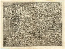
Nicolas Sanson's Gallia vetus ex C. Julii Caesaris commentariis descripta, ex conatibus... from delineates the ancient lands of Gaul as described in the commentaries of Julius Caesar. Rendered by the father of French cartography, this map is a scholarly representation of a region fundamental to the understanding of Western Europe's ancient past.
Sanson's map captures the extensive territories once known as Gaul, encompassing modern-day France and parts of Belgium, western Germany, and northern Italy. It delineates the intricate tribal boundaries and the Roman provincial divisions established during the Gallic Wars (58–50 BCE). The geography reflects the understanding of the time based on Caesar’s "Commentarii de Bello Gallico," a pivotal primary source for the period.
The map serves as a geographical narrative of the Roman conquest and subsequent transformation of Gaul. Sanson's depiction is not merely topographical but also a portrayal of the sociopolitical landscape of the time, indicating the locations of significant battles, tribal settlements, and the march of legions, thus providing an invaluable insight into the Roman military campaigns led by Caesar.
Nicholas Sanson (1600-1667) is considered the father of French cartography in its golden age from the mid-seventeenth century to the mid-eighteenth. Over the course of his career he produced over 300 maps; they are known for their clean style and extensive research. Sanson was largely responsible for beginning the shift of cartographic production and excellence from Amsterdam to Paris in the later-seventeenth century.
Sanson was born in Abbeville in Picardy. He made his first map at age twenty, a wall map of ancient Gaul. Upon moving to Paris, he gained the attention of Cardinal Richelieu, who made an introduction of Sanson to King Louis XIII. This led to Sanson's tutoring of the king and the granting of the title ingenieur-geographe du roi.
His success can be chalked up to his geographic and research skills, but also to his partnership with Pierre Mariette. Early in his career, Sanson worked primarily with the publisher Melchior Tavernier. Mariette purchased Tavernier’s business in 1644. Sanson worked with Mariette until 1657, when the latter died. Mariette’s son, also Pierre, helped to publish the Cartes générales de toutes les parties du monde (1658), Sanson' atlas and the first French world atlas.
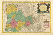
![[ Rare Imprint -- Theater of War in Europe ] Le Royaume de France divise en Toutes ses Provinces / Groot Toneel des Oorlogs, tusschen de Geallierrede Moghendhen en het Fransche Ryk -- Grand Theatre de la Guerre entre les Puissances Alliees et L'Empire Francois . . .](https://storage.googleapis.com/raremaps/img/small/104046.jpg)