|
||

|

|
|

|
"The Oldest General Map of the Dioceses of France." - David Gherdevich
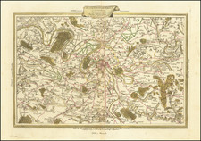
An exceptional map of France, showing the ecclesiastical (and, hence, jurisdictional) boundaries during the early 17th century. The map is astounding for its resemblance to the incunable maps which appeared over a century earlier, and its decorative tendencies are truly medieval despite its relatively humanist appeal. This very rare map was etched by H. Empereur and published by the French scholar des Bleyns in 1624. According to our research, this is the third known example of the map.
The design of the map is truly fantastic. The massively oversized cities are shown with buildings, walls, and, of course, churches. The mountains are gothic and rugged. Trees and forests are located where there are no cities or mountains. At sea, sailing ships and sea monsters abound, with the most imposing and impressive located at the mouth of the Seine.
A number of authors have called this the first ecclesiastical map of France. The start of the 17th-century saw several maps of individual diocese, for example, Jean des Biens Carte et Description Generale de Dauphine. . ., published in 1617, however, Des Bleyns is the first to extend these boundaries throughout the whole of France.
The immensely decorative appeal of the map should not distract from its importance as a primary source on the ecclesiastical division of France. Drawn from Des Bleyns's firsthand knowledge of the operation of the Church in France, it shows the boundaries between ecclesiastical (jurisdictional) provinces using dashed and dotted lines. Each diocese has a number of cities included, all of which start with the same letter. The city without a number following the letter is the archbishopric, while numbers denote the rankings of suffragan bishops, who (loosely, and not necessarily) diminish in importance the further they are from the archbishopric. This somewhat complicated concept is explained in detail in the text to the left of the map. To translate the useful analog provided:
Example A shows that Auch [in southwestern France] is an archbishopric. A1, Saint Legier, is the first suffragan dedicated to Ausch; A2 is Saint Bertrand is the second; A3, Tarbes, is the third; and so on all the way to A10, Bases, which is the tenth dedicated suffragan of Auche.
Des Bleyns was a professor of law (specifically canon law, it seems) at the University of Valence, in southeastern France. He published several important treatises on the French dioceses, foremost among them was his In theoriam et praxium beneficiorum ecclesiasticorum. . . His works are considered important humanist texts (Kondratuk) because of their reliance on ancient sources, including Cicero and Ovid, and his use of only the most central of Church canon works. These works helped reorient the French church as a partly secular organization.
Ecclesiastical jurisdiction is a complicated topic that deals with questions of temporal permanence and how the rule of a Divine Kingdom should be executed on earth, but, like all jurisdictions, it is made up of basic spatial units. As stipulated in the Council of Trent, bishops are endowed, as Papal delegates, with certain responsibilities to execute religious law. These (arch)bishops could themselves appoint aids, or "suffragan bishops," who would be responsible for the jurisdiction in their regions. This is the origin of dioceses as we now know them.
The geography on the map is outdated, but its blockish appearance appears to draw from Jean Jolivet's 1570 Vraie description de Gaules. . ., as ascribed by de Dainville. However, some differences can be noted in coastal regions, suggesting that the geography has been updated with other sources. The towns and borders shown are nearly certainly original research. In addition, there are a number of features that are of uncertain origin. For example, notice the tree at the source of the Vignone River and a number of other distinctly unusual features for which the sources are unknown.
The Latin text in the upper-left corner reads: Illustrissimi Santistitbus Caeterisque ex Genearli ac Sacro Totius Cleri Franciae Conventu Patridus Reverendissimis Opellam Hanc Topographicam N. Antonius Fabricius Bleynianus Iurisconsultus Neronensis et in Alma Valentinorum Universitate Antecessor Humiliter DD.
A line in the far lower-right corner of the map appears to read "H Empereur Sculpsit" but is far too burred to be legible. This is also the case with the BNF example of the map. Empereur is also credited below the legend in the left part of the map.
Rarity
No examples located in RBH nor in OldMaps.com.
OCLC records examples at the BnF and the Newberry Library.
Les cartes anciennes de l'Église de France sur la cartographie ecclésiastique du XVIe au XVIIIe siècle - Francois de Dainville
Les Institutiones iuris canonici de GP Lancellotti: l’émergence du systématisme moderne en droit canonique (XVIe-XVIIIe siècles) - Laurent Kondratuk
![[Portrait of Louis XV as a child] Ludovicus XV. Franciae et Navarrae Rex Natus 15 Febr. Anno 1710.](https://storage.googleapis.com/raremaps/img/small/95867.jpg)
![[France]](https://storage.googleapis.com/raremaps/img/small/77774.jpg)