


|
||

|

|
|

|
Stock# 102161
Description
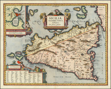
Attractive 18th-century map of the island and Kingdom of Sicily.
The bottom left corner features a small map of the islands of Malta and Gozo.
The map was published in Venice by Giovanni Antonio Remondini after having been first published by Paolo Santini in 1779.
Condition Description
Original hand-color in outline. Minor discoloration down center fold and minor ink smudges noted.
Paolo Santini Biography
Paolo Santini (1729-1793) was an Venetian engraver known especially for his religious prints and fine cartographic engravings. He published in Venice and may have a been a member of the clergy. In his maps, he largely adopted and adapted the work of his French counterparts, especially the brothers de Vaugondy.

![Secunda Africa Tabula [North Africa, Malta, Sicily, and Sardinia]](https://storage.googleapis.com/raremaps/img/small/72485.jpg)