|
||

|

|
|

|
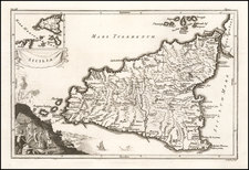
Nice old color example of Jansson's map of Ancient Sicily.
Includes a large inset map of the area around Naples and Syracuse, a decorative cartouche and key locating about 100 places on the map.
The map shows the island as it was during the period of Greek colonization and settlement, which lasted from the 8th century BC to the 3rd century BC. The map includes Greek city-states that existed on the island, such as Syracuse, Agrigento, and Gela, important landmarks, temples, theaters, and other public buildings.
Jan Janssonius (also known as Johann or Jan Jansson or Janszoon) (1588-1664) was a renowned geographer and publisher of the seventeenth century, when the Dutch dominated map publishing in Europe. Born in Arnhem, Jan was first exposed to the trade via his father, who was also a bookseller and publisher. In 1612, Jan married the daughter of Jodocus Hondius, who was also a prominent mapmaker and seller. Jonssonius’ first maps date from 1616.
In the 1630s, Janssonius worked with his brother-in-law, Henricus Hondius. Their most successful venture was to reissue the Mercator-Hondius atlas. Jodocus Hondius had acquired the plates to the Mercator atlas, first published in 1595, and added 36 additional maps. After Hondius died in 1612, Henricus took over publication; Janssonius joined the venture in 1633. Eventually, the atlas was renamed the Atlas Novus and then the Atlas Major, by which time it had expanded to eleven volumes. Janssonius is also well known for his volume of English county maps, published in 1646.
Janssonius died in Amsterdam in 1664. His son-in-law, Johannes van Waesbergen, took over his business. Eventually, many of Janssonius’ plates were sold to Gerard Valck and Pieter Schenk, who added their names and continued to reissue the maps.
![Insularum Aliquot Maris Mediterranei Descriptio [Sicily, Malta, Sardinia, Corfu, Elba and Zerbia] (1570A First State)](https://storage.googleapis.com/raremaps/img/small/87925.jpg)
![Tabula Aphricae II [Sicily & Sardinia shown]](https://storage.googleapis.com/raremaps/img/small/89727.jpg)
![Tavola Nuova Di Sardigna Et Di Sicilia [with Malta]](https://storage.googleapis.com/raremaps/img/small/103602.jpg)