|
||

|

|
|

|
Stock# 101907
Description
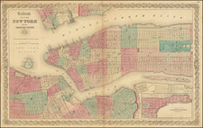
Fredrick W. Beers' Map of New York City and Brooklyn, published in 1873.
The map shows New York City to 115th Street and parts of Brooklyn and Queens.
Shows individual buildings, parks, and street names. Exceptional detail in Central Park and Queens, areas generally neglected by earlier maps of the city. Blackwood Island (Roosevelt Island) is beautifully detailed with a Hospital shown at the southern tip of the Island where today we see only a decrepit, if glorious, ruin. Shows the beginning of the Long Island Railroad at Hunter's Point and the individual buildings of the Lunatic Asylum on Ward's Island.
![(Second World War -- Navy Day -- Aircraft Carriers) New York City Navy Day 1945 [Panorama of Manhattan's West Side from Across the Hudson]](https://storage.googleapis.com/raremaps/img/small/95396.jpg)