|
||

|

|
|

|
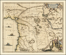
A handsome example of the Sanuto-Vesconte modern map of the Holy Land, from the 1486 Ulm Ptolemy, the first atlas printed north of the Alps.
"The map is orientated to the east and shows the whole of Palestine on both sides of the Jordan divided into the 12 Tribes. The shore line runs from Sidon to Gaza. South of a fantasy Carmel Mountain there is a big island, called the Castle of the Pilgrims (Atlit of today), and a similar but smaller island north of Jaffa called Assur. The Carmel Mountain is misshapen. The Jordan River in its wide meanderings is shown as a thin line" (Laor).
The Sanuto-Vesconte Prototype: The First "Modern" Map of the Holy Land
Kenneth Nebenzahl, in his groundbreaking cartobibliography Map of the Holy Land, includes the following essay on the Sanuto-Vesconte map of the Holy Land:
This "modern" map, copied directly from Sanuto and Vesconte by Donnus Nicholaus Germanus, is crucial for the development of Holy Land cartography during the early history of printing. It represents the second fundamental style, after Ptolemy's Asia Part IV, which determined the format for mapmakers of the sixteenth and seventeenth centuries. That the map was composed by Sanuto and Vesconte was no longer important; association with the atlases of Ptolemy assured its authority.
Nicholaus's copy is nearly identical to the 1320 original. Rivers, lakes, and mountains show the same basic contours, and the Mediterranean coast still has its characteristic bays and inlets. The boundaries of the Twelve Tribes are similar. A glance at the cities reveals a few discrepancies, but Sanuto-Vesconte's horizontal format and numerical grid are retained.
Nicholaus also made some improvements on Sanuto. Lines of latitude in the margin indicate that the orientation of Sanuto's map is actually to the southeast, not directly east; Nicholaus kept the format but indicated true north. The river Kishon no longer connects the Sea of Galilee with the Mediterranean, as it did according to Burchard of Mt. Sion's long-influential aberration. Some cities have been added, mostly from Ptolemy's Asia Part IV, and more information is conveyed in numerous inscriptions.
Nicholaus produced three manuscript versions of a Ptolemaic atlas between 1466 and 1474. These formed the basis for some of the first printed atlases, one at Rome in 1478, and two at Ulm in 1482 and 1486. The printed atlases contained Sanuto and Vesconte's map of Palestine as a modern map, linking them with the Ptolemaic canon.
Ptolemaic manuscripts had been supplemented by modern delineations as early as 1428, when a copyist inserted a map of the north by Claudius Clavus. Hugo de Comminellis produced a Ptolemy atlas with a section of modern maps in November 1469. Nicholaus, in his third revision of Ptolemy, quickly adopted Comminellis's original idea, adding Sanuto's map of the Holy Land for the first time.
The Sanuto-Vesconte map had not been improved substantially for over 150 years, and it was destined to provide the basic image of the Holy Land until the eighteenth century. It proved itself an appropriate addition to Ptolemy's classical geography.
The Ulm Ptolemy of 1482 and 1486
The Ulm edition of Ptolemy was first published in 1482 by Lienhart Holle. In contrast to the two earlier illustrated editions of Ptolemy's geography - Bologna (1477) and Rome (1478) - the maps in the Ulm edition are woodblock prints, not copperplate engravings. The maps in the Ulm edition follow the manuscript maps of Donnus Nicolaus Germanus, a Benedictine monk from Breslau who produced brilliant presentation copies for Italian elites in the 1460s and 1470s. Specifically, the Ulm was patterned after the manuscript atlas prepared for Pope Paul II. The Ulm Ptolemy was the first book Holle published, but it was also to be one of his last. Holle went bankrupt shortly after the original publication. The work was then taken over by Johann Reger, who issued another edition in 1486.
The differences between the two editions are relatively small. The 1486 maps typically include titles at the top, whereas there were no titles on the 1482 maps. An unpublished study of the individual maps reveals that there are multiple states of most of the maps.
It had long been suggested that the way to differentiate between the 1482 and 1486 editions was the use of lapis lazuli blue in the 1482 edition for the seas, whereas the 1486 used brown. However, the same unpublished study, which evaluated dozens of examples of the two editions, determined that the earliest examples of the 1486 were also issued with the lapis lazuli blue, suggesting that when Johann Reger acquired the woodblocks, he likely also acquired some unused lapis lazuli. In 2021, we offered for sale a complete example of a 1486 entirely in lapis lazuli blue.
Pietro Vesconte was a fourteenth-century mapmaker best known for his pioneering portolan charts. Born in Genoa, he performed the bulk of his work in Venice between 1310 and 1330.
While portolan charts are known to have existed since at least the thirteenth century, Vesconte significantly improved on the form and produced highly-accurate charts of the Mediterranean, the Black Sea, and Northern Europe. His 1311 chart of the eastern Mediterranean is the oldest signed and dated nautical chart. He also made at least four signed atlases. One of these, a 1318 atlas, includes an image of a chartmaker at work which is likely Vesconte. The cartographer also made several maps, including a distinctive mappa mundi included in Marino Sanuto’s Liber secretorum fidelium crucis.
![[ Gifted To Cecil B. De Mille by Elmer Bernstein ] (Mortier Bible) Histoire du Vieux et du Nouveau Testament Enrichie de plus de quatre cens Figures En Taille-Douce, &c. [2 vols in 1]](https://storage.googleapis.com/raremaps/img/small/96625.jpg)
![[Cyprus, Holy Land & Medina]](https://storage.googleapis.com/raremaps/img/small/87154.jpg)