|
||

|

|
|

|
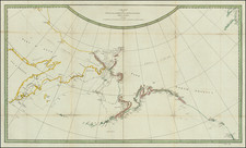
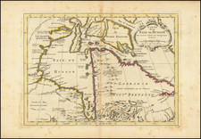
The First Aaccurate Geologic Map of Alaska and the Morthwestern Pacific Coast of North America
Fine example of this extremely rare map of Alaska and the Yukon, published by famed mineralogist Constantin Grewingk.
Constantine Grewingk, an esteemed Estonian geologist, collaborated with Ilya Gavrilovich Voznesenski to produce the inaugural geological map of Alaska in 1849, with the support of Mikhail D. Teben'kov, who became Governor of Russian America in 1845. Teben'kov conducted magnetic and meteorological studies from New Archangel (Sitka) and created essential navigational charts and a coastal hydrographical guide for contemporary sailors.
At Teben'kov's behest, St. Petersburg provided technical expertise for mineral surveys in the region. While Grewingk compiled the geological map during Peter Doroshin's mineral explorations in Alaska, the two never personally met, despite exchanging journal communications. Grewingk's map, which he compiled without doing fieldwork in Alaska, displayed an advanced understanding of the region's geology, including volcanic rocks, granite formations, metamorphic rocks, and coal-rich sedimentary basins.
Some of the data for the map was provided by Ilya Voznesensky, a notable figure in Russian-American scientific exploration, who first embarked on an influential expedition to Alaska in 1839. As a young apprentice in the Academy of Science in St. Petersburg, he developed a passion for zoology which led to his leadership role in collecting specimens across Russian America. His extensive travels in Alaska, including visits to Kodiak Island, Kenai, and the Pribilov Islands, resulted in a substantial collection of natural history and ethnographic artifacts. Returning to St. Petersburg in 1849 with thousands of specimens, Voznesensky's Alaskan collections have provided valuable insights into the region's biodiversity and cultural heritage, preserved in the Zoological Museum and the Museum of Anthropology and Ethnography.
The map offers a detailed study of the region focusing on the geological (geognostic) and mountainous (orographic) features of the Northwest coast of America and its nearby islands. The map bases its information on the cartographic work produced by the Hydrographic Department of the Russian Naval Ministry in St. Petersburg, incorporating Russian exploration and naval insights into the region. Pubished in 1850, it likely reflects mid-19th century knowledge and exploration efforts, during a time when the Russian Empire had a significant interest and presence in the North Pacific, including parts of what is today Alaska and the Aleutian Islands.
The map appeared in Grewingk's Beitrag zur Kenntniss der Orographischen und Geognostischen . . . published in St. Petersburg in 1850.
Rarity
The map is very rare. This is the first example we have ever seen.
Grewingk's geological work is also extremely rare. RBH note two examples offered in the past 100 years (Swann Galleries, 1975 and Eberstadt, 1941).
![[Alaska to San Diego and San Qunitin, British Columbia] A Chart Shewing Part of the Coast of N.W. America, with the Tracks of His Majesty's Sloop Discovery and Armed Tender Chatham . . . (First Modern Map of the West Coast of North America)](https://storage.googleapis.com/raremaps/img/small/102067.jpg)