


|
||

|

|
|

|
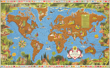
Rare portolan-style pictorial map of the world, celebrating the history of Portuguese discoveries and navigation.
This 1947 poster by Roberto Araujo, celebrates of Portugal's golden age of discovery. Lithographed in the historic city of Porto, the map delineates the expansive voyages of Portuguese explorers from 1482 to 1606, a time when the edge of the map was a place of myth and speculation, and beyond it lay only the imagination.
The map highlights the Portuguese contributions to global navigation and cartography, showing sea routes, marked with the names of the explorers in Portuguese. Each line traces the arduous journey of navigators who battled the unknown elements of the sea to connect continents and cultures.
The poster places particular emphasis on the pivotal voyages that reshaped world trade and geopolitics. It underscores Portugal's role in discovering the maritime paths that would become the arteries of global commerce and cultural exchange. Notably, the poster fantastically credits Portuguese explorers with the discovery of both the Northeast and Northwest Passages, along with proper credit to Magellan for his circumnavigation.
The visual elements of the poster, with its intricate compass roses and detailed coastal outlines, do more than just recount historical expeditions; they invoke the spirit of discovery that defined the age.
![[Los Angeles Olympic] O Limp Hicks Loose Anglaise Calif. 1932](https://storage.googleapis.com/raremaps/img/small/90509.jpg)

![The Seasoned Traveler Goes By Train [Map of Denver and Rocky Mountain National Park]](https://storage.googleapis.com/raremaps/img/small/99861.jpg)