


|
||

|

|
|

|
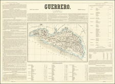
This 1897 map by Antonio García Cubas, published by Cadena y Ca and lithographed by Montauriol Sucesores, is a detailed portrayal of the state of Guanjuato, Mexico.
The map was issued as part of the Atlas Geografico de los Estados Unidos Mexicanos, a comprehensive atlas comprising 30 maps detailing Mexican states, the Federal District, and territories of Baja California and Tepic. This 1897 edition is distinguished by a new silver border, enhancing its visual appeal.
Antonio García Cubas, the esteemed 19th-century Mexican cartographer, was instrumental in illustrating Mexico's geographical and cultural landscape during a period of national consolidation and identity formation.
The map depicts various types of settlements such as capitals of states, head towns of districts, villages, and municipalities, as well as haciendas, ranchos, and mineral-rich areas, denoted by a detailed legend of symbols.
Includes the Central Railroad and a railroad under construction.
Antonio García y Cubas (1832-1912) was a Mexican geographer, historian, writer, and cartographer. An orphan from a young age, Cubas attended the Colegio de San Gregorio and the Colegio de Ingenieros, where he earned a geography degree. In 1856, he became a member of the Sociedad Mexicana de Geografía y Estadística.
Cubas wrote several geographic works, including introductory courses to geography, historical atlases, and maps. He is best known for his Atlas Geográfico, Estadístico e Histórico de la República Mexicana (1857), Carta General de México (1863), and Diccionario Geográfico, Histórico y Biográfico de los Estados Unidos Mexicanos en cinco volúmenes, editados entre 1888 y 1891. He is also praised for his memoir, El Libro de mis Recuerdos (1905). Today, the best books published in anthropology and history in Mexico are given the Antonio García Cubas prize.
![Mexico [with Southwestern U.S., Texas, etc.]](https://storage.googleapis.com/raremaps/img/small/97606.jpg)
![(Humboldt Atlas and Text) Geographique et Physique du Royaume de Nouvelle-Espagne [with quarto text:] Essai Politique de la Royaume de la Nouvelle-Espagne](https://storage.googleapis.com/raremaps/img/small/99796.jpg)
![Amer. Sep. No. 70. Partie Du Mexique [Acapulco]](https://storage.googleapis.com/raremaps/img/small/96401.jpg)
![(Mexican-Aztec Paintings) [Original watercolor of 4 Aztec Deities:] Tlaloque, God of water; Mayaguil, Goddess of Abundance on Agave Mexicana or Aloe; Xiuatlatl; Tezcatlipoca, Devil.](https://storage.googleapis.com/raremaps/img/small/103010.jpg)
![El numero 1 q[ue] se haya en la orilla de la ???ya que corre a San Ysidro es el gran ?? de partida siguencio? la numeracion immediata a los puntos amarillos ?on los ?inderos, hasta? el numero 19 con que vierra en el terreno marcados con la letra C.](https://storage.googleapis.com/raremaps/img/small/65664ba.jpg)